
Garagoa: Difference between revisions
m Bot: Migrating 1 interwiki links, now provided by Wikidata on d:q1524837 |
m En dash fix (via WP:JWB) |
||
| (27 intermediate revisions by 21 users not shown) | |||
| Line 1: | Line 1: | ||
{{Infobox settlement |
{{Infobox settlement |
||
|official_name |
| official_name = Garagoa |
||
| |
| image_skyline = Catedral Garagoa Año 2007.jpg |
||
| |
| image_caption = Church of Garagoa |
||
| |
| image_flag = Flag of Garagoa.svg |
||
| |
| image_seal = Escudo de Garagoa.svg |
||
| |
| nickname = |
||
| |
| motto = |
||
| |
| image_map = Colombia - Boyaca - Garagoa.svg |
||
| |
| mapsize = 250px |
||
| ⚫ | |||
|mapsize = 250px |
|||
| ⚫ | |||
| ⚫ | |||
|subdivision_type |
| subdivision_type = Country |
||
| subdivision_name = [[Colombia]] |
|||
|subdivision_type = '''Department''' |
|||
|subdivision_type1 |
| subdivision_type1 = Department |
||
| |
| subdivision_name1 = [[Boyacá Department|Boyacá]] |
||
| |
| subdivision_type2 = Province |
||
| subdivision_name2 = [[Neira Province|Neira]] |
|||
|leader_title = |
|||
| ⚫ | |||
|leader_name = |
|||
| established_date = 5 October 1809 |
|||
| ⚫ | |||
| |
| leader_title = Mayor |
||
| leader_name = Fabio Augusto Arévalo<br><small>(2020–2023)</small> |
|||
|area_magnitude = |
|||
| |
| area_total_km2 = 191.75 |
||
| |
| elevation_m = 1650 |
||
| population_total = 16944 |
|||
|area_land_sq_mi = |
|||
| population_as_of = 2015 |
|||
|area_land_km2 = |
|||
| ⚫ | |||
|area_water_sq_mi = |
|||
| ⚫ | |||
|area_water_km2 = |
|||
| population_density_mi2 = |
|||
|area_water_percent = |
|||
| ⚫ | |||
|area_urban_sq_mi = |
|||
| |
| timezone = -5 |
||
| |
| utc_offset = |
||
| |
| timezone_DST = |
||
| |
| utc_offset_DST = |
||
| ⚫ | |||
| ⚫ | |||
| |
| footnotes = |
||
|population_metro = |
|||
| ⚫ | |||
| ⚫ | |||
|population_density_sq_mi = |
|||
|timezone = -5 |
|||
|utc_offset = |
|||
|timezone_DST = |
|||
|utc_offset_DST = |
|||
|latd= |latm= |lats= |latN= |
|||
|longd= |longm= |longs= |longW= |
|||
|elevation_m = 1750 |
|||
|elevation_ft = |
|||
| ⚫ | |||
|footnotes = <sup>*</sup> |
|||
}} |
}} |
||
'''Garagoa''' is a town and [[municipality]] in [[Colombia]], located in the [[Boyacá Department]] It covers an area of |
'''Garagoa''' ({{IPA-es|ɡaɾaˈɣoa}}) is a town and [[municipality]] in [[Colombia]], located in the [[Boyacá Department]]. It covers an area of 191.75 km<sup>2</sup> and the urban centre is located at an altitude of {{convert|1650|m|ft}} above sea level. Parts of the municipality reach altitudes of {{convert|3050|m|ft}}. It is the capital of the province of [[Neira Province|Neira]]. It is also the seat of the [[Diocese]] of [[Roman Catholic Diocese of Garagoa|Garagoa]] of the Catholic Church. The municipality is situated in the [[Cordillera Oriental (Colombia)|Eastern Ranges]] of the Colombian [[Andes]] and borders [[Chinavita]] in the north, [[Macanal]] in the south, [[Tenza]] and [[Sutatenza]] in the west and [[Miraflores, Boyacá|Miraflores]] and Chinavita in the east.<ref name=websiteGaragoa>{{in lang|es}} [http://www.garagoa-boyaca.gov.co/ Official website Garagoa]</ref> |
||
== Etymology == |
|||
Garagoa was founded by Captain [[Gonzalo Jimenez de Quesada]] in 1539, and was elevated to municipal status in 1809. |
|||
Garagoa in [[Chibcha language|Chibcha]] means "Behind the hill" or "On the other side of the hill".<ref name=websiteGaragoa/><ref name=excelsio>{{in lang|es}} [http://www.excelsio.net/2011/11/sabe-el-origen-del-nombre-de-su.html Etymology Municipalities Boyacá] - Excelsio.net</ref> |
|||
== History == |
|||
| ⚫ | |||
In the times before the [[Spanish conquest of the Muisca|Spanish conquest]], the area of Garagoa was inhabited by the [[Muisca people|Muisca]], organized in their loose [[Muisca Confederation]]. Garagoa was ruled by the ''[[zaque]]'' based in [[Tunja|Hunza]]. Garagoa was visited by [[conquistador]] [[Gonzalo Jimenez de Quesada]] in 1539, and was elevated to municipal status on October 5, 1809.<ref name=websiteGaragoa/> |
|||
== |
== Economy == |
||
Main economical activities of Garagoa are [[agriculture]], [[livestock]] farming and [[mining]]. Among the agricultural products, most important are [[maize]], [[yuca]], [[potato]]es, [[arracacha]], [[banana]]s, [[pea]]s, [[bean]]s, [[pumpkin]]s, [[tomato]]es, [[fique]], [[coffee]] and [[sugar cane]]. Also [[mango]]es, [[chirimoya]], [[orange (fruit)|oranges]], [[avocado]]es, [[pineapple]]s, [[mandarin orange|mandarines]], [[papaya]]s, [[maracuyá]] and [[guayaba]] are produced. Mining is mostly [[coal]].<ref name=websiteGaragoa/> |
|||
== Trivia == |
|||
* The tree frog ''[[Dendropsophus garagoensis]]'' has been found in and named after Garagoa<ref>[http://amphibiaweb.org/cgi/amphib_query?where-genus=Dendropsophus&where-species=garagoensis ''Dendropsophus garagoensis'']</ref> |
|||
== Gallery == |
|||
<gallery> |
|||
File:Iglesia Garagoa.JPG|Church of Garagoa |
|||
File:Fuente-1.jpg|Fountain |
|||
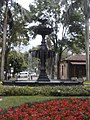
File:CAM00565.jpg|Central park and square |
|||
| ⚫ | |||
File:CAM00562.jpg|Central park |
|||
</gallery> |
|||
== References == |
|||
{{reflist}} |
|||
== External links == |
|||
* [http://www.catholic-hierarchy.org/diocese/dgara.html Diocese of Garagoa] |
* [http://www.catholic-hierarchy.org/diocese/dgara.html Diocese of Garagoa] |
||
* [http://www.garagoa-boyaca.gov.co Garagoa official website] |
|||
{{Municipalities boyaca department}} |
{{Municipalities boyaca department}} |
||
| ⚫ | |||
{{DEFAULTSORT:Garagoa, Boyaca}} |
{{DEFAULTSORT:Garagoa, Boyaca}} |
||
[[Category:Municipalities of Boyacá]] |
[[Category:Municipalities of Boyacá Department]] |
||
[[Category: |
[[Category:1809 establishments in the Spanish Empire]] |
||
[[Category:Populated places established in 1809]] |
|||
{{Boyacá-geo-stub}} |
|||
Latest revision as of 08:15, 2 May 2024
Garagoa | |
|---|---|
 Church of Garagoa | |
 Flag  Seal | |
 Location of the town and municipality of Garagoa in Boyacá Department | |
| Coordinates: 5°04′57″N 73°21′51″W / 5.08250°N 73.36417°W | |
| Country | Colombia |
| Department | Boyacá |
| Province | Neira |
| Founded | 5 October 1809 |
| Government | |
| • Mayor | Fabio Augusto Arévalo (2020–2023) |
| Area | |
| • City | 191.75 km2 (74.04 sq mi) |
| Elevation | 1,650 m (5,410 ft) |
| Population (2015) | |
| • City | 16,944 |
| • Density | 88/km2 (230/sq mi) |
| • Urban | 13,654 |
| Time zone | -5 |
| Website | Official website |
Garagoa (Spanish pronunciation: [ɡaɾaˈɣoa]) is a town and municipality in Colombia, located in the Boyacá Department. It covers an area of 191.75 km2 and the urban centre is located at an altitude of 1,650 metres (5,410 ft) above sea level. Parts of the municipality reach altitudes of 3,050 metres (10,010 ft). It is the capital of the province of Neira. It is also the seat of the Diocese of Garagoa of the Catholic Church. The municipality is situated in the Eastern Ranges of the Colombian Andes and borders Chinavita in the north, Macanal in the south, Tenza and Sutatenza in the west and Miraflores and Chinavita in the east.[1]
Etymology[edit]
Garagoa in Chibcha means "Behind the hill" or "On the other side of the hill".[1][2]
History[edit]
In the times before the Spanish conquest, the area of Garagoa was inhabited by the Muisca, organized in their loose Muisca Confederation. Garagoa was ruled by the zaque based in Hunza. Garagoa was visited by conquistador Gonzalo Jimenez de Quesada in 1539, and was elevated to municipal status on October 5, 1809.[1]
Economy[edit]
Main economical activities of Garagoa are agriculture, livestock farming and mining. Among the agricultural products, most important are maize, yuca, potatoes, arracacha, bananas, peas, beans, pumpkins, tomatoes, fique, coffee and sugar cane. Also mangoes, chirimoya, oranges, avocadoes, pineapples, mandarines, papayas, maracuyá and guayaba are produced. Mining is mostly coal.[1]
Trivia[edit]
- The tree frog Dendropsophus garagoensis has been found in and named after Garagoa[3]
Gallery[edit]
-
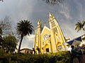 Church of Garagoa
 -
 Fountain
 -
 Central park and square
 -
 Tree in central park
 -
 Central park


References[edit]
- ^ a b c d (in Spanish) Official website Garagoa
- ^ (in Spanish) Etymology Municipalities Boyacá - Excelsio.net
- ^ Dendropsophus garagoensis