Bradford County, Pennsylvania: Difference between revisions
add details and source re derivation of county name |
added updated and current links |
||
| Line 141: | Line 141: | ||
==External links== |
==External links== |
||
*[http://www. |
*[http://www.bradfordcountypa.org/ Bradford County Government Information] |
||
*[http://www.bradfordhistory.com/ Bradford County Historical Society] |
|||
*[http://www.bradfordcountytourism.com/ Bradford County Tourist and Visitor Guide] |
|||
*[http://www.bradford-pa.com/ Bradford County General Information] |
|||
*[ftp://ftp.dot.state.pa.us/public/pdf/BPR_pdf_files/Maps/GHS/Roadnames/bradford_GHSN.PDF Pennsylvania Department of Transportation, Bureau of Planning and Research, Geographic Information Division, "2005 General Highway Map of Bradford County".] Note: shows boroughs, townships, roads, villages, some streams. URL accessed on April 6, 2006. |
*[ftp://ftp.dot.state.pa.us/public/pdf/BPR_pdf_files/Maps/GHS/Roadnames/bradford_GHSN.PDF Pennsylvania Department of Transportation, Bureau of Planning and Research, Geographic Information Division, "2005 General Highway Map of Bradford County".] Note: shows boroughs, townships, roads, villages, some streams. URL accessed on April 6, 2006. |
||
{{Bradford County, Pennsylvania}} |
{{Bradford County, Pennsylvania}} |
||
Revision as of 14:35, 27 August 2007
Bradford County | |
|---|---|
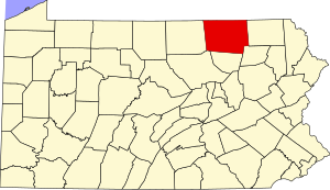
 Location within the U.S. state of Pennsylvania | |
 Pennsylvania's location within the U.S. | |
| Coordinates: 41°47′N 76°31′W / 41.79°N 76.52°W | |
| Country | |
| State | |
| Founded | February 21, 1810 |
| Seat | Towanda |
| Population (2000) | |
| • Total | 62,761 |
| Website | www |
Bradford County is a county located in the U.S. state of Pennsylvania. As of 2000, the population was 62,761. The county was created on February 21, 1810 from parts of Lycoming and Luzerne Counties. Originally called Ontario County, it was reorganized and separated from Lycoming County on October 13, 1812, and renamed Bradford County for William Bradford, who had been a chief justice of the Pennsylvania Supreme Court and United States Attorney General.[1] Its county seat is Towanda6. The county is not to be confused with the city of Bradford, which is in McKean County, many miles to the west.
Law And Government
Pennsylvania State Senate
Pennsylvania House of Representatives
- Matthew E. Baker, Republican, Pennsylvania's 68th Representative District
- Tina Pickett, Republican, Pennsylvania's 110th Representative District
United States House of Representatives
United States Senate
Geography
According to the U.S. Census Bureau, the county has a total area of 3,007 km² (1,161 mi²). 2,980 km² (1,151 mi²) of it is land and 27 km² (10 mi²) of it (0.89%) is water.
Adjacent Counties
- Chemung County, New York (north)
- Tioga County, New York (north)
- Susquehanna County (east)
- Wyoming County (southeast)
- Sullivan County (south)
- Lycoming County (southwest)
- Tioga County (west)
Demographics
As of the census² of 2000, there were 62,761 people, 24,453 households, and 17,312 families residing in the county. The population density was 21/km² (54/mi²). There were 28,664 housing units at an average density of 10/km² (25/mi²). The racial makeup of the county was 97.94% White, 0.40% Black or African American, 0.31% Native American, 0.45% Asian, 0.01% Pacific Islander, 0.19% from other races, and 0.69% from two or more races. 0.63% of the population were Hispanic or Latino of any race.
There were 24,453 households out of which 31.80% had children under the age of 18 living with them, 57.40% were married couples living together, 8.90% had a female householder with no husband present, and 29.20% were non-families. 24.70% of all households were made up of individuals and 11.50% had someone living alone who was 65 years of age or older. The average household size was 2.52 and the average family size was 2.99.
In the county, the population was spread out with 25.50% under the age of 18, 6.80% from 18 to 24, 27.20% from 25 to 44, 24.70% from 45 to 64, and 15.70% who were 65 years of age or older. The median age was 39 years. For every 100 females there were 95.10 males. For every 100 females age 18 and over, there were 92.10 males.
Municipalities

Under Pennsylvania law, there are four types of incorporated municipalities: cities, boroughs, townships, and, in at most two cases, towns. The following boroughs and townships are located in Bradford County:
Boroughs
Townships

Education
Public School Districts
- Athens Area School District
- Canton Area School District (also in Lycoming and Tioga Counties)
- Northeast Bradford School District
- Sayre Area School District
- Towanda Area School District
- Troy Area School District
- Wyalusing Area School District (also in Wyoming County)
Recreation
There is one Pennsylvania state park in Bradford County.
References
- ^ Bradford County History, Bradford County, Pennsylvania. Accessed August 21, 2007. "Founded in 1810, it was originally called Ontario, but the name was changed to Bradford in honor of U.S. Attorney General William Bradford, a member of George Washington's cabinet."
External links
- Bradford County Government Information
- Bradford County Historical Society
- Bradford County Tourist and Visitor Guide
- Bradford County General Information
- Pennsylvania Department of Transportation, Bureau of Planning and Research, Geographic Information Division, "2005 General Highway Map of Bradford County". Note: shows boroughs, townships, roads, villages, some streams. URL accessed on April 6, 2006.

