
Golubovci: Difference between revisions
No edit summary Tags: Mobile edit Mobile web edit |
removing hatnote per created page Tags: Mobile edit Mobile web edit |
||
| (36 intermediate revisions by 28 users not shown) | |||
| Line 1: | Line 1: | ||
{{Infobox settlement |
{{Infobox settlement |
||
| name |
| name = Golubovci |
||
| native_name |
| native_name = Голубовци |
||
| native_name_lang |
| native_name_lang = cnr |
||
| other_name |
| other_name = |
||
| settlement_type |
| settlement_type = [[List of cities in Montenegro|Town]] and [[Municipalities of Montenegro|city municipality]] |
||
| official_name |
| official_name = |
||
| nickname |
| nickname = |
||
| motto |
| motto = |
||
| image_skyline |
| image_skyline = Podgorica airport.jpg |
||
| imagesize |
| imagesize = |
||
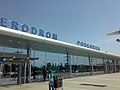
| image_caption |
| image_caption = [[Golubovci Airport]], near town of Golubovci |
||
| image_flag |
| image_flag = |
||
| flag_size |
| flag_size = |
||
| |
| image_shield = |
||
| |
| shield_alt = 70px |
||
| image_map |
| image_map = |
||
| mapsize |
| mapsize = |
||
| map_caption |
| map_caption = |
||
| pushpin_map |
| pushpin_map = Montenegro |
||
| pushpin_label_position |
| pushpin_label_position = left<!-- the position of the pushpin label: left, right, top, bottom, none --> |
||
| pushpin_map_caption |
| pushpin_map_caption = Location within Montenegro |
||
| pushpin_mapsize |
| pushpin_mapsize = <!-- Location ------------------> |
||
| ⚫ | |||
<!-- Location ------------------> |
|||
| ⚫ | |||
| ⚫ | |||
| ⚫ | |||
| ⚫ | |||
| subdivision_name1 = Zeta |
|||
| ⚫ | |||
| government_footnotes = |
|||
| subdivision_name1 = [[File:Podgorica Coat of Arms.png|15px]] [[Podgorica Capital City|Podgorica]] |
|||
| |
| government_type = |
||
| |
| leader_title = President |
||
| |
| leader_name = Mihailo Asanović ([[Democratic People's Party (Montenegro)|DNP]]) |
||
| established_title = |
|||
| leader_name = Tanja Stajović ([[Democratic Party of Socialists|DPS]]) |
|||
| |
| established_date = |
||
| |
| area_magnitude = |
||
| |
| unit_pref = Imperial |
||
| |
| area_footnotes = |
||
| |
| area_total_km2 = |
||
| |
| area_land_km2 = |
||
| |
| population_as_of = 2011 |
||
| |
| population_footnotes = |
||
| ⚫ | |||
| population_footnotes = |
|||
| population_blank1 = 16,093 |
|||
| ⚫ | |||
| |
| population_note = |
||
| population_density_km2 = |
|||
| population_note = |
|||
| |
| population_urban = 3,110 |
||
| |
| population_rural = 12,983 |
||
| |
| timezone = [[Central European Time|CET]] |
||
| |
| utc_offset = +1 |
||
| |
| timezone_DST = [[Central European Summer Time|CEST]] |
||
| |
| utc_offset_DST = +2 |
||
| |
| coordinates = {{coord|42|20|4|N|19|13|31|E|display=inline}} |
||
| elevation_footnotes = |
|||
| coordinates = {{coord|42|20|4|N|19|13|31|E|display=inline}} |
|||
| |
| elevation_m = |
||
| |
| elevation_ft = |
||
| |
| postal_code_type = Postal code |
||
| |
| postal_code = 81304 |
||
| |
| area_code = +382 20 |
||
| |
| registration_plate = ZT |
||
| |
| blank_name = [[Köppen climate classification|Climate]] |
||
| |
| blank_info = [[Humid subtropical climate|Cfa]] |
||
| |
| website = |
||
| |
| footnotes = |
||
| footnotes = |
|||
}} |
}} |
||
'''Golubovci''' ({{lang-cnr|Голубовци}}, {{IPA-sh|ɡǒluboʋtsi|pron}}) is a small [[town]] in the new [[Zeta Municipality]] of [[Montenegro]]. Until 2022, it was part of [[Podgorica Municipality]].<ref>{{cite web | last=Obradović | first=Aleksandra | title=Zeta becomes municipality from today | website=CdM | date=23 August 2022 | url=https://www.cdm.me/english/zeta-becomes-municipality-from-today/ | access-date=6 March 2024}}</ref> |
|||
The town has 3,110 residents according to 2011 census,<ref>{{cite web|website=monstat.org |
|||
'''Golubovci''' ({{lang-sr-cyrl|Голубовци}}, {{IPA-sh|ɡǒluboʋtsi|pron}}) is a small [[town]] in the [[Podgorica Capital City|Podgorica Municipality]] of [[Montenegro]]. |
|||
| ⚫ | |url=http://www.monstat.org/userfiles/file/popis2011/podaci%20naselja/Tabela%20N1.xls|title=Population and Housing Census in Montenegro - ethnicity}}</ref> while the surrounding Zeta Municipality accounts for some 16,093 residents.<ref>{{cite web|url= http://monstat.org/userfiles/file/popis2011/saopstenje/knjiga_prvi%20rezultati(1).pdf |title=2011 Census Preliminary Results }}</ref> |
||
| ⚫ | |||
==Transport== |
==Transport== |
||
[[Podgorica Airport]] is occasionally referred to as Golubovci Airport by locals, due to its proximity to the town. |
|||
| ⚫ | Golubovci is located next to the [[M-2 highway (Montenegro)|M-2]], Podgorica - [[Bar, Montenegro|Bar]] road ([[European route E65|E65]]/[[European route E80|E80]]), main Montenegrin road connection between the coast and northern part of the country. Part of this road went through the centre of Golubovci causing frequent traffic jams during the summer tourist season which led to construction of 4-lane [[dual carriageway]], the Golubovci Bypass, in 2018.<ref>{{Cite web|url=http://podgorica.me/2018/10/10/pokrenuta-akcij-uredenje-koridora-obilaznice-oko-naselja-golubovci/|title=Pokrenuta akcija uređenje koridora obilaznice oko naselja Golubovci|date=October 10, 2018|website=Glavni Grad Podgorica|access-date=October 12, 2019}}</ref> |
||
==Sports== |
==Sports== |
||
The town is home to [[FK Zeta]], one of the most successful Montenegrin football clubs in recent years. They play their home games at the [[Stadion Trešnjica]]. The town's basketball team is [[KK Zeta 2011]]. |
The town is home to [[FK Zeta]], one of the most successful Montenegrin football clubs in recent years. They play their home games at the [[Stadion Trešnjica]]. The town's basketball team is [[KK Zeta 2011]]. |
||
==Ethnic composition== |
==Ethnic composition== |
||
===Town (2011)=== |
===Town (2011) === |
||
| ⚫ | |||
Source:<ref>{{Cite web|url=http://monstat.org/cg/page.php?id=536&pageid=322|title=Uprava za statistiku Crne Gore - MONSTAT}}</ref> |
|||
| ⚫ | |||
| ⚫ | |||
| ⚫ | |||
| ⚫ | |||
| ⚫ | |||
*Others 81 (2.6%) |
*Others 81 (2.6%) |
||
*Total - 3,110 |
*Total - 3,110 |
||
===Municipality (2011)=== |
===Municipality (2011)=== |
||
*Montenegrins - 10,574 (65.15%) |
*Montenegrins - 10,574 (65.15%) |
||
| Line 89: | Line 91: | ||
*Total - 16,093 |
*Total - 16,093 |
||
== |
==Municipality== |
||
Town of Golubovci is the seat of the ''' |
Town of Golubovci is the seat of the recently created '''Zeta Municipality''' ([[Montenegrin language|Montenegrin]]: ''Opština Zeta'' / Општина Зета). The town is located some 15 km south of the city of [[Podgorica]], in the fertile [[Zeta Plain]] (Zetska ravnica). |
||
===Gallery=== |
===Gallery=== |
||
<gallery> |
<gallery class="center"> |
||
File:Golubovci Urban Municipality, Montenegro - panoramio (4).jpg|[[Skadar lake]] |
File:Golubovci Urban Municipality, Montenegro - panoramio (4).jpg|[[Skadar lake]] |
||
File:Podgorica-Tuzi plantaze wineyard IMG 1319.JPG|[[Zeta plain]] |
File:Podgorica-Tuzi plantaze wineyard IMG 1319.JPG|[[Zeta plain]] |
||
| Line 111: | Line 113: | ||
{{coord|42|20|4|N|19|13|31|E|display=title}} |
{{coord|42|20|4|N|19|13|31|E|display=title}} |
||
[[Category:Populated places in |
[[Category:Populated places in Zeta Municipality]] |
||
{{Montenegro-geo-stub}} |
{{Montenegro-geo-stub}} |
||
Latest revision as of 17:35, 4 May 2024
Golubovci
Голубовци | |
|---|---|
 Golubovci Airport, near town of Golubovci | |
 Golubovci Location within Montenegro | |
| Coordinates: 42°20′4″N 19°13′31″E / 42.33444°N 19.22528°E | |
| Country | |
| Municipality | Zeta |
| Government | |
| • President | Mihailo Asanović (DNP) |
| Population (2011) | |
| • Urban | 3,110 |
| • Rural | 12,983 |
| • Urban municipality | 16,093 |
| Time zone | UTC+1 (CET) |
| • Summer (DST) | UTC+2 (CEST) |
| Postal code | 81304 |
| Area code | +382 20 |
| Vehicle registration | ZT |
| Climate | Cfa |
Golubovci (Montenegrin: Голубовци, pronounced [ɡǒluboʋtsi]) is a small town in the new Zeta Municipality of Montenegro. Until 2022, it was part of Podgorica Municipality.[1]
The town has 3,110 residents according to 2011 census,[2] while the surrounding Zeta Municipality accounts for some 16,093 residents.[3]
Transport[edit]
Podgorica Airport is occasionally referred to as Golubovci Airport by locals, due to its proximity to the town.
Golubovci is located next to the M-2, Podgorica - Bar road (E65/E80), main Montenegrin road connection between the coast and northern part of the country. Part of this road went through the centre of Golubovci causing frequent traffic jams during the summer tourist season which led to construction of 4-lane dual carriageway, the Golubovci Bypass, in 2018.[4]
Sports[edit]
The town is home to FK Zeta, one of the most successful Montenegrin football clubs in recent years. They play their home games at the Stadion Trešnjica. The town's basketball team is KK Zeta 2011.
Ethnic composition[edit]
Town (2011)[edit]
Source:[5]
- Montenegrins - 1,920 (61.7%)
- Serbs - 844 (27,4%)
- No response - 265 (8.5%)
- Others 81 (2.6%)
- Total - 3,110
Municipality (2011)[edit]
- Montenegrins - 10,574 (65.15%)
- Serbs - 4,190 (25.81%)
- Others/unspecified - 1,467 (9.04%)
- Total - 16,093
Municipality[edit]
Town of Golubovci is the seat of the recently created Zeta Municipality (Montenegrin: Opština Zeta / Општина Зета). The town is located some 15 km south of the city of Podgorica, in the fertile Zeta Plain (Zetska ravnica).
Gallery[edit]
-

-

-
-
 Dodoši, Skadar lake
 -
 Žabljak Crnojevića castle
 -
 Vranjina island
 -
 Lesendro fortress
 -

.jpg)


.jpg)
.jpg)


References[edit]
- ^ Obradović, Aleksandra (23 August 2022). "Zeta becomes municipality from today". CdM. Retrieved 6 March 2024.
- ^ "Population and Housing Census in Montenegro - ethnicity". monstat.org.
- ^ "2011 Census Preliminary Results" (PDF).
- ^ "Pokrenuta akcija uređenje koridora obilaznice oko naselja Golubovci". Glavni Grad Podgorica. October 10, 2018. Retrieved October 12, 2019.
- ^ "Uprava za statistiku Crne Gore - MONSTAT".

42°20′4″N 19°13′31″E / 42.33444°N 19.22528°E
This Montenegro location article is a stub. You can help Wikipedia by expanding it. |