Spruce Knob–Seneca Rocks National Recreation Area: Difference between revisions
Content deleted Content added
Keystone18 (talk | contribs) mNo edit summary |
m checkwiki error, fixed syntax, default sort |
||
| (2 intermediate revisions by one other user not shown) | |||
| Line 1: | Line 1: | ||
{{Infobox protected area |
{{Infobox protected area |
||
| name = Spruce |
| name = Spruce Knob–Seneca Rocks National Recreation Area |
||
| iucn_category = |
| iucn_category = |
||
| iucn_ref = |
| iucn_ref = |
||
| Line 51: | Line 51: | ||
}} |
}} |
||
'''Spruce |
'''Spruce Knob–Seneca Rocks National Recreation Area''' is a [[national recreation area]] in the [[Monongahela National Forest]] of eastern [[West Virginia]]. |
||
The |
The national recreation area protects three prominent West Virginia landmarks: |
||
* [[Spruce Knob]], the highest point in West Virginia (and the highest of the [[Allegheny Mountains]]) with a summit elevation of 4,863 feet (1482 m). |
* [[Spruce Knob]], the highest point in West Virginia (and the highest of the [[Allegheny Mountains]]) with a summit elevation of 4,863 feet (1482 m). |
||
* [[Seneca Rocks]], a 900-foot (270 m) high [[quartzite]] [[cliff|crag]] popular with [[rock climbers]]. |
* [[Seneca Rocks]], a 900-foot (270 m) high [[quartzite]] [[cliff|crag]] popular with [[rock climbers]]. |
||
* [[Smoke Hole Canyon]], a canyon along the [[South Branch Potomac River]]. |
* [[Smoke Hole Canyon]], a canyon along the [[South Branch Potomac River]]. |
||
Spruce |
Spruce Knob–Seneca Rocks National Recreation Area was established by an act of the [[United States Congress|U.S. Congress]] on September 28, 1965, as the first national recreation area in a [[United States National Forest]], so it is administered by the [[U.S. Forest Service]]. |
||
==See also== |
==See also== |
||
| Line 84: | Line 84: | ||
{{WestVirginia-protected-area-stub}} |
{{WestVirginia-protected-area-stub}} |
||
{{PotomacHighlandsWV-geo-stub}} |
{{PotomacHighlandsWV-geo-stub}} |
||
{{DEFAULTSORT:Spruce Knob-Seneca Rocks National Recreation Area}} |
|||
Latest revision as of 02:17, 30 January 2023
| Spruce Knob–Seneca Rocks National Recreation Area | |
|---|---|
 | |
Location of Spruce Knob-Seneca Rocks National Recreation Area in West Virginia | |
| Location | West Virginia, U.S. |
| Coordinates | 38°50′02″N 79°22′04″W / 38.83389°N 79.36778°W |
| Area | 100,000 acres (400 km2)[1] |
| Elevation | 1,923 ft (586 m) |
| Established | 1965-09-28 |
| Operator | Monongahela National Forest |
| Website | Spruce Knob-Seneca Rocks National Recreation Area |
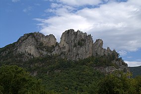
Spruce Knob–Seneca Rocks National Recreation Area is a national recreation area in the Monongahela National Forest of eastern West Virginia.
The national recreation area protects three prominent West Virginia landmarks:
- Spruce Knob, the highest point in West Virginia (and the highest of the Allegheny Mountains) with a summit elevation of 4,863 feet (1482 m).
- Seneca Rocks, a 900-foot (270 m) high quartzite crag popular with rock climbers.
- Smoke Hole Canyon, a canyon along the South Branch Potomac River.
Spruce Knob–Seneca Rocks National Recreation Area was established by an act of the U.S. Congress on September 28, 1965, as the first national recreation area in a United States National Forest, so it is administered by the U.S. Forest Service.
See also[edit]
References[edit]
- ^ Monongahela National Forest: Spruce Knob-Seneca Rocks National Recreation Area, accessed July 23, 2013.
External links[edit]
Wikimedia Commons has media related to Spruce Knob-Seneca Rocks National Recreation Area.
Categories:
- Protected areas of Grant County, West Virginia
- National Recreation Areas of the United States
- Protected areas of Pendleton County, West Virginia
- Protected areas of West Virginia
- Protected areas established in 1965
- 1965 establishments in West Virginia
- West Virginia geography stubs
- Southern United States protected area stubs
- Potomac Highlands geography stubs

