Åkersberga
| Åkersberga | ||||
|
||||
| State : | Sweden | |||
| Province (län): | Stockholm County | |||
| Historical Province (landskap): | Uppland | |||
| Municipality : | Österåker | |||
| Coordinates : | 59 ° 29 ′ N , 18 ° 18 ′ E | |||
| SCB code : | 0408 | |||
| Status: | Crime scene | |||
| Residents : | 32,659 (December 31, 2015) | |||
| Area : | 24.6 km² | |||
| Population density : | 1328 inhabitants / km² | |||
| Postal code : | 184 00 | |||
| List of perpetrators in Stockholm County | ||||
Åkersberga is a locality ( tätort ) in the Swedish province of Stockholm County and capital of the municipality of Österåker . Between 1974 and 1983 Åkersberga was the main town in the municipality of Vaxholm .
Sculpture at the fire station
history
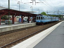
Åkersberga has a relatively short history and owes its existence mainly to the establishment of the Södra Roslags Kustbana railway line and its proximity to Stockholm. In 1901 a train station was set up at Berga Manor . In order to avoid confusion with other places with the same name, the station was named Åkers Berga, as it was located in the former Åkers skeppslag administrative area. The current name developed from this later. Until shortly after the Second World War, the area around the station had grown into an urban settlement.
Since 2015, the previously independent towns of Hagbyhöjden and Norrö have been part of the Åkersberga crime scene, while Spånlöt in the east of the town has been spun off as a new crime scene.
traffic
Länsväg 276 runs through Åkersberga . With the L28 railway line, known as Roslagsbanan, which ends in the Österskär district, the place is connected to Stockholm's public transport network.
sons and daughters of the town
- Ola Andersson (born 1966), football player
- Mattias Gustafsson (* 1978), handball player
- Alexander Östlund (* 1978), football player
- Loreen (* 1983), Swedish singer
Web links
Individual evidence
- ↑ a b Statistiska centralbyrån : Land area per Tatort, folkmängd and invånare per square kilometer. Vart femte år 1960 - 2015 (database query)


