Ólmod
| Ólmod | ||||
|
||||
| Basic data | ||||
|---|---|---|---|---|
| State : | Hungary | |||
| Region : | Western Transdanubia | |||
| County : | Vas | |||
| Small area until December 31, 2012 : | Kőszeg | |||
| District since 1.1.2013 : | Kőszeg | |||
| Coordinates : | 47 ° 25 ' N , 16 ° 35' E | |||
| Area : | 3.66 km² | |||
| Residents : | 100 (Jan. 1, 2011) | |||
| Population density : | 27 inhabitants per km² | |||
| Telephone code : | (+36) 94 | |||
| Postal code : | 9733 | |||
| KSH kódja: | 22044 | |||
| Structure and administration (as of 2015) | ||||
| Community type : | local community | |||
| Mayor : | Vince Hergovich (independent) | |||
| Postal address : | Fő utca 25 9733 Ólmod |
|||
| (Source: A Magyar Köztársaság helységnévkönyve 2011. január 1st at Központi statisztikai hivatal ) | ||||
Ólmod ( Croatian Plajgor , German Bleigraben ) is a Hungarian municipality in Vas County .
location
Ólmod is not even a kilometer away from the border with Austria . The Via Sancti Martini pilgrimage route runs through the village .
Attractions
- Local history collection Koreni ( Gyökerek Helytörténeti Gyűjtemény )
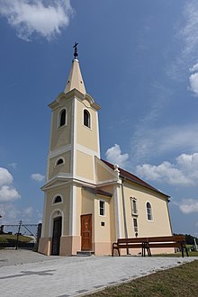
- Roman Catholic Church Szent Márton , built in 1722 (Baroque)
- Roman Catholic Chapel ( Belovich-kápolna )
traffic
There is a bus connection via Horvátzsidány to Kőszeg and in the direction of Bük . The nearest train station is in Kőszeg.
Web links
Commons : Ólmod - collection of images, videos and audio files


