
Cák
| Cák | |||||
|
|||||
| Basic data | |||||
|---|---|---|---|---|---|
| State : | Hungary | ||||
| Region : | Western Transdanubia | ||||
| County : | Vas | ||||
| Small area until December 31, 2012 : | Kőszeg | ||||
| District since 1.1.2013 : | Kőszeg | ||||
| Coordinates : | 47 ° 21 ' N , 16 ° 31' E | ||||
| Area : | 6.48 km² | ||||
| Residents : | 294 (Jan. 1, 2011) | ||||
| Population density : | 45 inhabitants per km² | ||||
| Telephone code : | (+36) 94 | ||||
| Postal code : | 9725 | ||||
| KSH kódja: | 08271 | ||||
| Structure and administration (as of 2015) | |||||
| Community type : | local community | ||||
| Mayoress : | Józsefné Paukovics (independent) | ||||
| Postal address : | Petőfi S. u. 31 9725 Cák |
||||
| Website : | |||||
| (Source: A Magyar Köztársaság helységnévkönyve 2011. január 1st at Központi statisztikai hivatal ) | |||||


Cák ( German Zackenbach , Croatian Caka ) is a Hungarian municipality in Vas county near the Austrian border, four kilometers southwest of Kőszeg ( Güns ) on the slopes of the Güns Mountains .
history
Tombs from Roman times have been found in Cák; The place was first mentioned in documents in 1279 as Villa Chak . The Turks destroyed the village in 1532, and Christian soldiers burned the place down in 1573 and 1606.
The inhabitants were engaged in fruit and wine growing, but the phylloxera invasion in the 19th century caused great damage. Viticulture was rebuilt, but most of the residents were already making a living from growing chestnuts and fruit. The old wine cellars are now a listed building . There is a former quarry north of the village .
Today the community has about 294 inhabitants.
Attractions
- Roman Catholic Church of St. Peter and St. Paul ( Szent Péter és Pál apostolok ), built in 1894 according to plans by the Viennese architect Ludwig Schöne
- Old wine cellars from the 18th and 19th centuries
photos
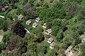
Aerial view of Cák
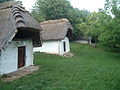
Old wine cellar

Entrance

View of the Roman Catholic Church


Web links
- Cák ( Hungarian )
- Savaria Museum (Hungarian)