
Kiszsidány
| Kiszsidány | |||||
|
|||||
| Basic data | |||||
|---|---|---|---|---|---|
| State : | Hungary | ||||
| Region : | Western Transdanubia | ||||
| County : | Vas | ||||
| Small area until December 31, 2012 : | Kőszeg | ||||
| District since 1.1.2013 : | Kőszeg | ||||
| Coordinates : | 47 ° 25 ' N , 16 ° 38' E | ||||
| Area : | 17.65 km² | ||||
| Residents : | 98 (Jan. 1, 2011) | ||||
| Population density : | 6 inhabitants per km² | ||||
| Telephone code : | (+36) 94 | ||||
| Postal code : | 9733 | ||||
| KSH kódja: | 15486 | ||||
| Structure and administration (as of 2019) | |||||
| Community type : | local community | ||||
| Mayor : | Zoltán Bánó (independent) | ||||
| Postal address : | Fő utca 2 9733 Kiszsidány |
||||
| Website : | |||||
| (Source: A Magyar Köztársaság helységnévkönyve 2011. január 1st at Központi statisztikai hivatal ) | |||||


Kiszsidány ( German Roggendorf , Croatian Lukindrof ; until 1946 Németzsidány ) is a municipality in the district of Kőszeg in Vas County in western Hungary .
geography
Geographical location
The municipality is located about seven kilometers northeast of Kőszeg , a good 20 kilometers north of Szombathely and three kilometers south of the border with Austria . Neighboring municipalities are Horvátzsidány , Peresznye and Csepreg .
history
The village was founded after 1236 and is said to have got its name (Roggendorf) from a submerged predecessor settlement called Rokfia . The place was a German-speaking island in a part of Hungary that had been mostly Croatian populated since the 16th century. In 1946 the village was renamed from Németzsidány ("German Zsidany") to Kiszsidány ("Klein Zsidany").
population
| Ethnic structure | ||||||||
|---|---|---|---|---|---|---|---|---|
| year | Residents | Magyars | German | Croatians | Others | |||
| 1880 | 357 | 7th | 316 | 13 | 21st | |||
| 1910 | 303 | 12 | 266 | 10 | 15th | |||
| 1920 | 296 | 35 | 235 | 13 | 13 | |||
| 1930 | 237 | 31 | 201 | 5 | 0 | |||
| 1941 | 244 | 46 | 192 | 6th | 0 | |||
| 1949 | 241 | 236 | 1 | 4th | 0 | |||
| 2011 | 98 | - | - | - | - | |||
Attractions
- Bell tower of the Protestant church, built in 1926
- Virgin Mary statue ( Szűz Mária-oszlop )
- Rhododendron garden ( Rododendron kert )
- Roman Catholic Church Szűz Mária neve , built in 1882
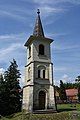
Bell tower of the Protestant church

Roman Catholic Church of Sz Máz Mária neve


traffic
Road No. 8624 runs on the northern edge of the village. There are bus connections to Kőszeg and in the direction of Bük . The nearest train station is about eight kilometers southwest in Kőszeg.
Web links
- Official website ( Hungarian )
- Kiszsidány near Geschrittenstein Nature Park
- Kiszsidány at Via Sancti Martini
Individual evidence
- ↑ Helyi önkormányzati választások 2019 - Kiszsidány (Vas megye). Nemzeti Választási Iroda, accessed December 15, 2019 (Hungarian).
- ↑ Kiszsidány. In: Magyarország helységnévtára. Központi Statisztikai Hivatal, accessed December 15, 2019 (Hungarian).
- ^ Fritz Zimmermann: The Carolingian settlement area of Lutzmannsburg. In: Burgenland homeland sheets . 10th year, issue No. 1, Eisenstadt 1948, p. 4, PDF on ZOBODAT