
Floods in the Pyrenees in 2013
| Deep Manni | |
|---|---|
| classification | Heavy rain with melting snow ( flash floods ) |
| Data | |
| Climax | 17th-19th June 2013 |
| consequences | |
| affected areas | West and Central Pyrenees : Spain , France |
| Victim | 3 |
Heavy rainfall from June 17, 2013 in the French and Spanish Pyrenees , together with the resulting snowmelt, led to floods in the Pyrenees in 2013 .
meteorology
The reason for the event was a smaller Biscay low (named by DWD Lars and Manni ), which then settled over Spain and France for a few days. On its front, it led humid Mediterranean air masses towards the Pyrenees.
Météo-France had issued storm warnings from June 17 , the warnings were only lifted on June 19. In Vielha , in the 24 hours 17th to 18th, 115 liters / m² of rain were measured. In winter there was up to 4 meters of snow, the largest amount since 1980. In total, precipitation and melt mass reached a record value that had not yet occurred since measurements began in 1959. The area had already had a long period of bad weather (in the vicinity of the heavy floods in central Europe at the beginning of June ), so that the water flowed off immediately. The Gave de Pau reached record levels at several levels. In Spain, the maximum flow rates were 10 to 20 times the normal ( Noguera Pallaresa 160 m³ / s, Noguera Ribagorçana 190 m³ / s).
The north side of the Pyrenees was more severely affected, while on the south side the levels of the flood of October 2012 , which had been the worst event in 50 years, were generally not quite reached.
consequences
France

The upper reaches of the Garonne and the valley of the Gave de Pau were particularly affected .
The media reported a total of three deaths (in Lourdes , Luz-Saint-Sauveur , Cauneille ). Especially the water masses of the Garonne caused numerous landslides and washed away several houses, streets, bridges and countless trees. Several disaster management plans ( cellulles de crise ) have been put in place in the Haute-Garonne and Hautes-Pyrénées departments . The authorities evacuated 3,000 people.
In the pilgrimage site of Lourdes on the banks of the Gave de Pau, the underground basilica of Pius X was flooded, the Bernadette basilica from the 19th century and the Marian grotto itself were also affected. In the city, damage in the double-digit million range was incurred, which significantly exceeded the cost of the floods that had recently occurred in October 2012.
The Pays Toy valley on the Bastan in the Adour catchment area was also badly affected .
Around 9 million euros in aid were paid out in the Garonne area.
- Visible destruction after the flood

Destroyed bridge in the Lys valley south of Bagnères-de-Luchon
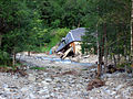
Destroyed house in the Lys valley south of Bagnères-de-Luchon

Landslide at Gavarnie on Gave de Gavarnie Ou de Pau

Landslide near Héas in the Vallée du Gave de Héas


Spain
In Spain, Ésera , Noguera Pallaresa , Noguera de Cardós and other mountain streams in the Val d'Aran , Pallars Sobirà , Alta Ribagorça and the north of Pallars Jussà were affected by the floods.
In Catalonia , people had to be evacuated from several villages. Several bridges and streets as well as individual houses were destroyed.
The flooding events led to a review of the scenarios used and to a refinement of the disaster plans.
literature
- Nicolas Hérbert (Ed.): Quand l'eau tombe en excès. In: AudourGaronne , 123, September 2013, pp. 14–22 ( pdf , on eau-adour-garonne.fr).
- Jean-Sébastien Gion: Les crues du 18 juin 2013. Web document, undated - Meteorological analysis in the context of the record winter
- Roberto Serrano-Notivoli, Daniel Mora Mur, Alfredo Ollero Ojeda, Miguel Sánchez Fabre, Miguel Ángel Saz Sánchez: Respuesta hidrológica al evento de precipitación de junio de 2013 en el Pirineo central / Hydrological response to precipitation event on June 2013 in central Pyrenees. In: Universidad de Alicante. Instituto Interuniversitario de Geografía Investigaciones Geográficas 62, 2014, pp. 5–21; doi: 10.14198 / INGEO2014.62.01 ( download pdf on rua.ua.es).
Web links
- Les inondations des 18 et 19 June 2013. Agence de l'eau Adour-Garonne (December 20, 2013) - with video, photos and download of the Hérbert dossier: Quand l'eau tombe en excès .
- Une eau de "Lourdes" conséquences. Equipe RME de l'académie de Rouen (November 2013) - with weather maps, photos, damage overview France.
- Floods in Southern France (2013-06-18). European Commission, Joint Research Center (JRC), data.europa.eu - download of event cards
- Vulnerabilidad de los territorios frente a las inundaciones. Nicolas Lechat, Laure Rolland, on the website of the Observatorio Pirenaico del Cambio Climático (opcc-ctp.org, undated) - pictures, further links
- Inondations (Sud Ouest) - Mardi 18 juin 2013 au Vendredi 21 juin 2013. memoiresdescatastrophes.org - pictures
Individual evidence
-
↑ Forecast for Mon June 17, 2013, 12:00 UTC. DWD weather map, website of the Free University of Berlin;
Weather situation as of June 17, 2013, 12 UTC. ZAMG: Current weather map and map archive ;
NCEP, June 17, 2013, 7:00 p.m. locale. Meteofrance, meteociel.fr. - ↑ Forecast for Wed June 19, 2013, 12:00 UTC. DWD; Weather situation from June 19, 2013, 12 UTC. ZAMG; NCEP, June 19, 2013, 7:00 p.m. locale. meteociel.fr.
- ↑ a b c d Maria-Helena Ramos: Flash floods in the French western and central Pyrenees (17-19 June 2013). on hepex.irstea.fr, from June 25, 2013 (accessed January 5, 2018).
- ↑ a b c d e Severe floods in the north-western Catalan Pyrenees. In: CatalaNews , June 19, 2013.
- ↑ a b Natalie Bargerie: Météo: un hiver et un printemps hors-norme. In: Lit. Hérbert, 2013, p. 15 f (pdf 2 f).
- ↑ 120 Días: ¿Un invierno con más nieve de lo habitual? Uso de la teledetección para el seguimiento del manto de nieve en los Pirineos. Observatorio Pirenaico del Cambio Climático (opcc-ctp.org), June 2013.
- ↑ a b c d Floods in France June 2013. floodlist.com, June 20, 2013.
- ↑ cf. Central Europe 72h rain fall at June 2, 2013.png Wikimedia image file - the Pyrenees region at the edge of the image.
- ↑ Roberto Serrano-Notivoli, D. Mora, Alfredo Ollero, Miguel Sánchez Fabre, P. Sanz, Miguel Ángel Saz: Floodplain occupation and flooding in the Central Pyrenees. In: Cuadernos de Investigación Geográfica 43, October 2016, doi: 10.18172 / cig.3057 ( researchgate.net , preview and download) - Investigations on Aragón and Ésera .
- ↑ a b c Scott Sayare (2013) Flooding Damages Lourdes, French Holy Site. In: New York Times online, June 19, 2013.
- ^ Sud-Ouest: un 3e mort après une crue exceptionnelle qui a devasté Lourdes. LaDepeche.fr, June 19, 2013.
- ↑ See web link RME / Rouen.
- ^ Floods in Lourdes after heavy rains , Belgischer Rundfunk, June 18, 2013.
- ↑ Floods in Lourdes cause millions in damage , kath.net, June 23, 2013.
- ↑ K. Bazile, S. Casamayor, M. Chérigié, G. Clain, L. Clérima, Y. Diagana, L. Foumou, O. Gachet, A. Olive; A. Peltier, JM Antoine (Re.): La crue de juin 2013 en vallée de Barèges - L'évènement et ses conséquences neuf mois plus tard. Dossier as part of the Cruespyr 2013 project , May 2014 ( cruespyr2013.canalblog.com : pdf , geode.univ-tlse2.fr).
- ↑ cf. to Crue du 18 juin 2013 en pays Toy , French Wikipedia.
- ↑ Web link Agence de l'eau Adour-Garonne.
- ↑ Ane Victoriano Lamariano, M. García-Silvestre, Glòria Furdada i Bellavista and Jaume Bordonau i Ibern (2016) Long-term entrenchment and consequences for present flood hazard in the Garona River (Val d'Aran, Central Pyrenees, Spain). Published by the European Geosciences Union (EGU) as part of Natural Hazards And Earth System Sciences , 2016, vol. 16, pp. 2055-2070; doi : 10.5194 / nhess-16-2055-2016 .