Aabach (Küttigen)
|
Aabach Left main line upper course : Wilenbergbach Middle reaches : Vorstadtbach |
||
|
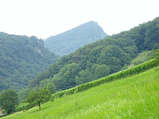
View through the banks of the Aabach to the summit of the Wasserfluh above its source |
||
| Data | ||
| Water code | CH : AG570646 | |
| location |
Kanton Aargau
|
|
| River system | Rhine | |
| Drain over | Aare → Rhine → North Sea | |
| source | southwest of the Wasserflue 47 ° 25 ′ 40 ″ N , 8 ° 1 ′ 2 ″ E |
|
| Source height | approx. 700 m | |
| muzzle | in Küttigen from the north-west into the Aare Coordinates: 47 ° 24 '22 " N , 8 ° 3' 37" E ; CH1903: 646929 / 250788 47 ° 24 '22 " N , 8 ° 3' 37" O |
|
| Mouth height | 360 m | |
| Height difference | approx. 340 m | |
| Bottom slope | approx. 68 ‰ | |
| length | 5 km | |
| Catchment area | 8.96 km² | |
| Discharge A Eo : 8.96 km² at the mouth |
MQ Mq |
140 l / s 15.6 l / (s km²) |
| Left tributaries | Fischbach, Horenbach | |
The Küttiger Aabach is about five kilometers long, has a catchment area of less than nine square kilometers and is a left tributary of the Aare in the Aarau district of the Swiss canton of Aargau .
geography
course
It rises in the Küttiger municipality at 700 m above sea level in a Jura high valley southwest of the peaks Wasserflue (865 m) and Wilenberg (803 m) and northeast of the Erlinsbach town of Hard. At its upper reaches it is also called Wilenbergbach. About two and a half kilometers it flows between two ridges of the mountains to the east to the inlet of the much shorter left Fischbach and then breaks in the Bänker chlus in a steady southeast direction from now on through the right of the Jura ridges . After the bend in the run, it runs through the settlement area of Küttigen, initially under the name Vorstadtbach, almost lengthways. The longest tributary, the Horenbach, flows deep in the lower reaches in front of the outdoor swimming pool, coming from the north through the Asperchlus. The Aabach itself finally flows below the village at 360 m above sea level at Küttigen-Schürmatt from the northwest into the left, northwest arm of the Aare , 41.6 km before it joins the Rhine .
Tributaries
- Fischbach, left
- Horenbach, left
See also
- Aabach (Seetal) , right tributary of the same name of the Aare further down
Individual evidence
- ↑ a b c Geoserver of the Swiss Federal Administration ( information )
- ↑ a b Topographical catchment areas of Swiss waters: sub-catchment areas 2 km². Retrieved June 8, 2019 .
