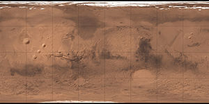
Acidalia Planitia
| Great Plain on Mars | ||
|---|---|---|
| Acidalia Planitia | ||

|
||
| Topographic map of the Acidalia Planitia region | ||
|
|
||
| position | 50 ° N , 21 ° W | |
| expansion | 3363 km | |
Acidalia Planitia is a lowland plain on the planet Mars .
Areography
location
The vast plain is in the northern hemisphere of the planet, centered at latitude 49.8 ° north and longitude 339.3 ° east. It lies within the Mare Acidalium Gradfeld , north of the Valles Marineris , between the volcanoes of the Tharsis region to the west and the Arabia Terra bordering to the southeast . There it forms a dark spot, which is why it is already clearly visible from Earth with telescopes. The plain contains the Cydonia region , which also forms the boundary between it and the southern highlands of the planet.
Due to the low location and the resulting lower radiation exposure from the sun , the plain is often considered for future manned missions to Mars .
Surface structures
crater
In contrast to the uneven, southern highlands, the Acidalia plain has very few craters , as its surface is much younger and has often been deformed by volcanism and / or liquid water. The few existing craters are probably relatively old, which is indicated above all by the small amount of erosion . They probably only formed after the liquid water on the surface of Mars had disappeared, which meant that they could neither be removed by water masses nor replenished by mud deposits. In the west, however, there are also some older craters up to 20 kilometers in diameter. These were apparently filled with sediments and broken up by pent-up water masses, as the river valleys still recognizable today suggest.

River valleys
There are further, numerous and widely branched river valleys in the transition area between the highlands and the lowlands. These mostly tree-shaped channel patterns were probably formed in primeval times by rain or snow. The existence of these river valleys indicates the warmer and more humid climate as well as the higher atmospheric pressure of Mars in the past, since these properties are necessary to enable liquid water on the surface.
hill
In addition to the craters and river valleys, the Acidalia Plain is covered by tens of thousands of round, bright hills about a kilometer in size. What exactly this is about has not yet been finally clarified. It is believed that they were caused by lava cones, ice deposits (similar to pingos ) or mud volcanoes .
To the south of the plain is the famous face of Mars .
Oceans
It is possible that the Acidalia Plain, along with the Utopia Planitia and other lowlands, was once covered by a vast ocean . This points z. B. the similar crater density . According to findings from measurement data from ESA's Mars Express probe , the plain could even have been covered by an ocean in two different ages. The first ocean was formed about four billion years ago, when Mars still had a denser atmosphere and a warmer climate. This disappeared after Mars lost a large part of its atmosphere in a climate change, which is necessary for the maintenance of surface water. The second ocean was formed around a billion years later when subterranean water ice was melted to the surface by volcanic eruptions in the Tharsis region or an asteroid impact . The sediments in the water temporarily protected it from evaporating due to solar radiation. However, this theory has not yet been fully proven.
Astrobiology
The area is interesting from an astrobiological point of view, as the clear evidence of crater lakes, river valleys and a possible ocean confirm the earlier occurrence of surface water and, according to general opinion, this is a necessary basic requirement for the development and further development of life. The plane could therefore be considered for future research missions looking for signs of past or still present life.
Origin of name
The plain is named after a corresponding albedo feature of an early mapping of Mars by the astronomer Giovanni Schiaparelli . Schiaparelli, in turn, named this after the mystical fountain of Acidalia , in which, according to legend, the daughters of the goddess Venus bathed.
Occurrence in conversation
Acidalia Planitia is one of the main locations in the science fiction film The Martian - Saves Mark Watney . In the film, this is the base station of the fictional Ares III mission, to which astronaut Mark Watney returns to fight for his survival after he was left alone on the planet by the rest of the crew because he was lost in a violent sandstorm .
Web links
Individual evidence
- ↑ a b Acidalia Planitia in the Gazetteer of Planetary Nomenclature of the IAU (WGPSN) / USGS . June 1, 2016, accessed March 28, 2020.
- ↑ a b Martian landscapes - scinexx | The knowledge magazine. Retrieved March 27, 2020 .
- ↑ a b c Raumfahrer net Editor: Mars Express: The Plain Acidalia Planitia. Retrieved March 27, 2020 .
- ↑ MA Ivanov, H. Hiesinger, G. Erkeling, D. Reiss: Evidence for large reservoirs of water / mud in Utopia and Acidalia Planitiae on Mars . In: Icarus . tape 248 , March 1, 2015, ISSN 0019-1035 , p. 383–391 , doi : 10.1016 / j.icarus.2014.11.013 ( sciencedirect.com [accessed March 27, 2020]).
- Jump up ↑ New Evidence for a Previous Ocean on Mars. In: raumfahrer.net. February 7, 2012, accessed March 29, 2020 .
- ↑ Space com Staff 19 July 2016: Acidalia Planitia - Fact Meets Fiction | Space wallpaper. Retrieved April 26, 2020 (English).
