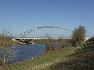
Agnes Bernauer Bridge (Straubing)
Coordinates: 48 ° 53 ′ 51 ″ N , 12 ° 34 ′ 51 ″ E
| Agnes Bernauer Bridge | ||
|---|---|---|
| Official name | Agnes Bernauer Bridge | |
| use | Road bridge | |
| Convicted | State Road 2141 | |
| Crossing of | Old Danube at km 2320.0 | |
| place | Straubing | |
| Building number | 7141 548 | |
| construction | Steel arch bridge | |
| overall length | 152 m | |
| width | 17.0 m | |
| Longest span | 152 m | |
| Load capacity | Grade 60 | |
| start of building | October 1979 | |
| completion | November 1981 | |
| location | ||
|
|
||
The Agnes-Bernauer-Brücke connects the inner island of Gstütt with the Hornstorf district in the urban area of Straubing . The bridge crosses the Old Danube at river kilometer 2,320.00 in the course of the state road 2141. The bridge has the building number 7141 548.
construction
It is a steel tied arch bridge with a roadway below and a span of 152 meters. The concrete abutment has a clear width of 150.60 meters. The vertical parabolic steel arches have welded box sections with a width of 0.66 m and a height of 1.12 m. They are connected to one another by a postless diamond-shaped wind bracing and portal bars. The two external stiffening girders with the orthotropic deck slab are removed over the 23.5 meter high arches by 10 hangers each 13.82 m apart and 90 millimeters in diameter.
history
The new building from 1981 replaces the old Outer Danube Bridge at the same location . The new building was necessary in the course of the expansion of the Danube, as the waterway was relocated from the Straubing lock into the Old Danube .
Naming
Before the Danube was moved past the Ducal Castle in 1480, there was only one bridge in Straubing, which was later the outer Danube bridge. If Agnes Bernauer was actually thrown from the Danube Bridge in 1435, it was close to the current Agnes Bernauer Bridge .
Predecessor structures
The previous structures called Äussere Brücke crossed the Chaussee called Böhmerstraße to the east of the current location .
In 1938 a steel girder bridge with three spans and a span of 142.05 meters was built. Its clearance height of 3.17 meters and the center distance of the river pillars of 54.63 meters did not constitute an obstacle to shipping, as the waterway still ran past the Ducal Castle under the castle bridge , which was blown up on April 26, 1945. It was rebuilt between 1947 and December 1950. After the Agnes-Bernauer Bridge was completed, it was demolished.
In 1809 a ship bridge was built from pontoons with a fixed bridgehead. The pontoons were captured by the French in Passau. Before 1809 there was a simple trestle bridge, 396 shoes (115.6 meters) long and made up of 11 yokes .
literature
- Wolfgang Bach, Hans Vicari: Straubing Danube bridges . Attenkofer, Straubing 1994, ISBN 978-3-9802955-6-7 .
Web links
Individual evidence
- ↑ Photo of the building number
- ↑ Directory of the bridge clearance heights / widths in the district of WSD South. (PDF) (No longer available online.) Federal Waterways and Shipping Administration , May 2013, archived from the original on December 27, 2013 ; Retrieved August 3, 2014 .
- ↑ Outer Danube Bridge Straubing. In: brueckenweb.de. Retrieved August 3, 2014 .
- ↑ Road bridge Agnes-Bernauer-Brücke. (JPG) In: WMS Inland ENCs. Federal Waterways and Shipping Administration , archived from the original on August 8, 2014 ; accessed on August 8, 2014 .
- ↑ Straubinger Wochenblatt, Volume 16. January 15, 1824, p. 449 , accessed on August 9, 2014 .
- ↑ Martin Sieghart: History and Description of the Capital Straubing in the Lower Danube District of the Kingdom of Bavaria, Volume 2. 1835, p. 173 , accessed on August 9, 2014 .
- ^ Adrian von Riedl : Reise Atlas von Bajern or geographic-geometric representation of all Bavarian main and country roads with [...] Lentner, 1805 ( digital copy ).

