Alet (salad)
| Alet | ||
|
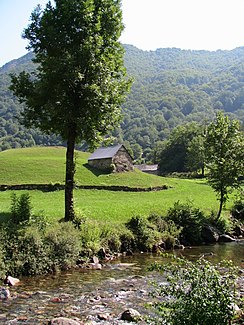
The river at Ustou |
||
| Data | ||
| Water code | FR : O0310500 | |
| location | France , Occitania region | |
| River system | Garonne | |
| Drain over | Salad → Garonne → Atlantic Ocean | |
| source | in the municipality of Ustou 42 ° 43 ′ 29 ″ N , 1 ° 18 ′ 14 ″ E |
|
| Source height | approx. 2101 m | |
| muzzle | at the point of contact of the municipalities of Seix , Ustou and Couflens in the Salat coordinates: 42 ° 49 ′ 54 ″ N , 1 ° 11 ′ 54 ″ E 42 ° 49 ′ 54 ″ N , 1 ° 11 ′ 54 ″ E |
|
| Mouth height | approx. 560 m | |
| Height difference | approx. 1541 m | |
| Bottom slope | approx. 77 ‰ | |
| length | approx. 20 km | |
| Flowing lakes | Etang de la Hillette | |
The Alet is a river in France that runs in the Ariège department in the Occitanie region . It has its source in the Pyrenees , near the border with Spain , in the southern municipality of Ustou , between the Pointe de la Hillette and the Campet summit (2312 m). The source stream is named Ruisseau de la Hillette , flows through the mountain of the same name Etang de la Hillette and then falls over the valley Cirque de Cagateille steeply to the valley. There it changes its name again to Ruisseau des Cors , drains generally in a north-westerly direction through the Pyrénées Ariégeoises Regional Nature Park and flows into the right tributary after a total of around 20 kilometers at the point of contact between the communities of Seix , Ustou and Couflens , at the hamlet of Pont de la Taule the salad .
Places on the river
(Order in flow direction)
Hamlet of the municipality of Ustou :
- Moussures
- Stillon
- L'Ariail
- Portet
- Saint Lizier
- Bielle
- Le Trein
- Pont de la Taule
