
Old grain market
| Old grain market | |
|---|---|
|
|
|

|
|
| Basic data | |
| place | regensburg |
| District | Downtown |
| Created | approx. 175 AD |
| Newly designed | 1964 ( tram shutdown ) |
| Confluent streets |
Domstrasse, Speichergasse, Pfluggasse, Kapellengasse, Niedermünstergasse |
| Buildings |
Herzogshof , Römerturm , Old Chapel , Carmelite Church of St. Josef , Carmelite Monastery of St. Josef , Stift Niedermünster , Dompfarrkirche Niedermünster , document niedermünster |
| use | |
| User groups | Pedestrian traffic, bicycle traffic, public transport, road traffic |
| Space design | Pavement, parking lots, green spaces |


|

|
|
|
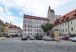
Old Kornmarkt north side, west town houses, east Niedermünster
|
||

|

|
|
|
Old Kornmarkt east side, north of Niedermünster and a former pharmacy, south of the Carmelite monastery with the beginning of Maximilianstrasse
|
||

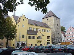
The Alte Kornmarkt is an almost square square with a side length of approx. 80 m in the northeast area of the old town of Regensburg . The basic shape of the square goes back to a square inner fort , which was newly built in the northeast area of the large Roman military camp Castra Regina with a side length of approx. 450 m after the buildings of the large fort were destroyed by fire in 357. At the Kornmarkt is the Herzogshof , the residence of the Bavarian dukes, the most important secular building in Regensburg, the oldest of which is older than the town hall . The square is not yet part of the restricted traffic zone in the city center, has to cope with through traffic and offer parking spaces.
Historical meaning
The Old Corn Market has always been a focal point of lordly and religious life and action since Roman times during the times of the Bavarians , the dukes of the Agilolfingers , the Carolingian emperors and kings, the Saxon emperors , up to the Wittelsbachers , who became dukes of Bavaria in 1180. This time ended when the Wittelsbach family left their residence in the Herzogshof in 1245 after Regensburg had been promoted to the status of a Free Imperial City . The Kornmarkt became one of many squares in the imperial city, but retained a special significance because of the territorial rights of the Bavarian dukes that continued to exist on the square, because of the important churches and monasteries surrounding and neighboring the square, and because of its size.
Surname
The name of the square and the addition "Alter" refer to the grain market, which took place on the square until 1825 and was then moved to Haidplatz . From 1893 to 1907 the square was named after Field Marshal Helmut von Moltke .
location
The old grain market is only a little to the east of the cathedral , from which it is only separated by the cathedral courtyard with buildings, the St. Ulrich church and the Roman tower . The Römerturm clearly delimits the Old Kornmarkt at the northwest end, but it was not part of the Roman military camp, but rather belonged to the ensemble of the Herzogshof and Königspfalz . Under the Schwibbogen between the Römerturm and the neighboring Herzogshof to the south, a road allows passage from the Kornmarkt to the west to Albrecht Altdorfer Platz and the Domplatz . Further narrow streets lead from Kornmarkt to the north, to the Danube , to the east to the Dachauplatz with Schwanenplatz and to the south-west, past the free-standing bell tower of the old chapel, the pedestrian zone and the Neupfarrplatz . The main access road to the Alter Kornmarkt is the approx. 800 m long, relatively wide Maximilianstrasse , running in north-south direction , which today leads to the train station and was only built shortly after 1809. Maximilianstrasse crosses the district to the south of the Old Kornmarkt, which was destroyed in 1809 during the Napoleonic battles for Regensburg and was then rebuilt with new, mostly economical buildings and straight streets.
Development
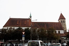
The old grain market is surrounded on all sides by representative buildings, some of which are closely related to the early days of Regensburg. The buildings are recorded, described and shown in the list of architectural monuments in Regensburg-Zentrum . In the west is the Herzogshof and the Roman tower connected to it by a flying buttress. In the north there are town houses to the west and the buildings of the Niedermünster monastery to the east with the monastery church and monastery school, today's Niedermünster girls' secondary school . The Mohrenapotheke was housed in the northern corner building on Pfluggasse from 1864 to 2016 . To the south of Pfluggasse, the east side of the square is dominated by the front of the Carmelite Church of St. Joseph with accompanying buildings. In the south of the square, hidden behind a row of trees, you can see the collegiate church of the old chapel with the free-standing bell tower. Buildings of Roman origin from the 2nd and 3rd centuries are presumed beneath the surface of the square, including bathing buildings, crew quarters and a magnificent building for the commandant of the Roman camp.
use
Until the beginning of the 20th century, when the square was used, curious disputes - from today's perspective - between the city of Regensburg and the governor of the Duke of Bavaria, who resided in the Herzogshof, over the territorial rights over the old grain market.
- There is evidence of a blacksmith's workshop with Romanesque components for 1326, which was built on to the north of the Roman tower, protruded into the square and was structurally changed in the Baroque period. The open extension, supported by wooden pillars, dates from the 16th century and was used to shoe horses that could be tied to iron rings in the east wall of the Roman tower.
- In 1392 there was a big knight stinging ceremony for which a large part of the Bavarian nobility had gathered on the square, which was cordoned off by chains. Even if the construction of the Carmelite Monastery was not finished until 1655, the size of the square was suitable even before the construction of the magnificent facade of the monastery to offer a representative backdrop for appropriate occasions. There are reports of other tournaments and military shows that took place with imperial and princely splendor.
- In 1452 the most famous traveling preacher of his time, the Franciscan Johannes von Capestrano , appeared in Regensburg and preached on the square against viciousness and gambling addiction in front of thousands of listeners for whom the square had been filled with straw. The audience's game boards, dice and cards could be burned on a burning pile of wood.
- In 1541 great pageantry was displayed for Emperor Charles V , who presented himself to the people with great pomp on the occasion of a Reichstag together with electors and princes on a large platform in front of the ducal court.
- 1551 and also for 1644, a fountain in the square is detectable from the newly opened office in Brunn Dechbetten was fed and served together with other wells supplying the population. Because the water flow was too weak in the long run, another well room was opened on the Eisbuckel in 1656.
- In 1559 the city built a large wooden shed on the east side of the square to store boards there.
- In 1633, Georg Wolmar von Fahrensbach, the city commander of Ingolstadt, was executed on the Alter Kornmarkt during the Thirty Years' War . He had tried to hand over the Bavarian fortress to the Swedes. The conspiracy was discovered and Elector Maximilian of Bavaria did not miss the opportunity to demonstrate his power as ruler in the Protestant imperial city of Regensburg, which he occupied at the time, by executing on the old corn market in front of the ducal court, where he had domiciliary rights. On May 10, 1633 Fahrensbach was beheaded under dramatic circumstances. He had initially resisted his execution and was then killed together by 3 executioners.
- In 1641 the construction of the Carmelite Monastery of St. Joseph, completed in 1655, began on the east side of the square in place of an inn and the old bishops' courts of Freising and Bamberg.
- In 1782, the French ambassador, Count von Bombelle, had an avenue of trees planted on the south side along the facade of the Old Chapel, where a row of trees can still be found today.
- Before 1903 a large fountain was built.
- From 1903 Two lines of the new tram in Regensburg lead over the old Kornmarkt until 1964?
- In 1938 the Alte Kornmarkt was better connected to the neighboring Domplatz and the cathedral by a pedestrian passage designed as a two-part arcade .
- After 1964? Beginning of the extensive use of the old grain market as a passage for through traffic, as a parking lot for cars and as a location for sales stands.
- Views of the square with stationary traffic

North side with towers Niedermünsterkirche

North side cutout
Nordosteck Niedermünster, former pharmacy
South side with parking lot in the foreground
West side Herzogshof foreground, parking lot, background kebab shop


- 2012 The weekly vegetable market ( Danube market ) on Saturday is assigned the old grain market as a new location , but keeps the old name in the vernacular. The use of the space as a parking lot and thoroughfare is restricted on Saturday for half a day.
- In 2018, after years of discussions in the city council, broader public discussions and campaigns to clear the old grain market from stationary and flowing traffic, with the intention of giving the square a new face that corresponds to its historical significance.
Web links
Individual evidence
- ^ Sigfrid Färber: Regensburg, then, yesterday and today. The image of the city over the last 125 years . JF Steinkopf Verlag, Stuttgart 1984, ISBN 3-7984-0588-3 , p. 21 .
- ^ Karl Bauer: Regensburg art, culture and everyday history . MZ Buchverlag, Regensburg 2014, ISBN 978-3-86646-300-4 . P. 57ff
- ^ A b Karl Bauer: Regensburg art, culture and everyday history . MZ Buchverlag, Regensburg 2014, ISBN 978-3-86646-300-4 . P.56
- ^ Karl Bauer: Regensburg art, culture and everyday history . MZ Buchverlag, Regensburg 2014, ISBN 978-3-86646-300-4 . P. 58
- ^ Karl Bauer: Regensburg art, culture and everyday history . MZ Buchverlag, Regensburg 2014, ISBN 978-3-86646-300-4 . Pp. 875, 879
- ^ A b Karl Bauer: Regensburg art, culture and everyday history . MZ Buchverlag, Regensburg 2014, ISBN 978-3-86646-300-4 . P. 57
- ^ Max Neubauer: Elector Maximilian I of Bavaria, the Habsburgs and the imperial city of Regensburg in the struggle for their sovereignty . Dissertation University of Regensburg Philosophical Faculty III, 2011. (p. 114, footnote 604)
- ^ Karl Bauer: Regensburg art, culture and everyday history . MZ Buchverlag, Regensburg 2014, ISBN 978-3-86646-300-4 . P. 928f

Coordinates: 49 ° 1 '8.2 " N , 12 ° 6' 0.7" E