
Old town (Passau)
|
Old town
City of Passau
Coordinates: 48 ° 34 ′ 30 ″ N , 13 ° 28 ′ 0 ″ E
|
|
|---|---|
| Height : | 290 m above sea level NN |
| Residents : | 3067 (Dec. 31, 2005) |
| Postal code : | 94032 |
| Area code : | 0851 |

Districts of Passau , the old town is shown in white
|
|
 Historical maps of the old town of Passau from 1827
|
|
The old town is a district of the university town of Passau in the Bavarian administrative district of Lower Bavaria with 3,067 inhabitants (4,679 including secondary residences) (population register as of December 31, 2005). The old town represents the historical center of Passau.
history
Here was from around 15 BC. BC to 50 AD the Celtic oppidum Boiodurum, in its place around 150 the Roman fort Batavis was built. Around 280 the camp village of Castra Batava was built at the tip of the headland . The fort was cleared in late Roman times, the first Bavarian (7th century) and later Carolingian (8th century) ducal court became the seat of a bishopric in 739.


The cathedral with the episcopal property has since formed its center . To the east of it, the bourgeois town developed with the market square, today Residenzplatz. The free merchants who were directly subordinate to the emperor lived here. The property of the Niedernburg monastery lay further east . The monastery of St. Nikola , which belonged to the Duchy of Bavaria was already abroad and unbolted from spreading further to the west. The geographical and also political cramped conditions forced a particularly dense construction method in the old town, which still exists today in numerous, often extremely narrow streets.
From the 10th to the 13th century, a suburban settlement, the "Neumarkt", developed west of the cathedral. It became the main business center of the city and in 1209 it was enclosed with walls. In 1662 and 1680 devastating fires raged in the old town. The buildings erected during the reconstruction gave the old town its relatively uniform baroque character. The town houses in the Inn-Salzach style with their ditch roofs followed precise building regulations due to the risk of fire.
The headland of the tip of the village in the far east, on which there was a gravel pit, already belonged to the municipality of Grubweg . It was leased by the city of Passau in 1891, filled up and later planted with poplars. On October 23, 1952, the municipal council of Grubweg left the tip of the town of Passau, but it was not until January 1, 1956 that the incorporation became legally binding.
structure

The district extends from the top of the village in the east to the Schanzlbrücke in the west. But it also includes a part to the left (north) of the Danube around the fortress Oberhaus . The area, including the shares in the rivers, is 152.6 hectares . It is divided into five districts, two of which are on the right (south) of the Danube with 68 hectares and three on the left (north) of the Danube:
Old town center
The district of Altstadt Ortsmitte , d. H. the old town in the colloquial sense, extends from the headland in the east to the cathedral square in the west, to the old city wall. The town hall square with town hall and seat of the city administration is also located here.
Neumarkt
The district of Neumarkt connects to the west of the district of Altstadt Ortsmitte and extends to the west as far as Schanzlbrücke and Nikolastraße. The district developed from the 10th to the 13th century as a suburban settlement west of the cathedral. It was enclosed with a city wall in 1209. It developed into the most important business center of Passau.
Anger
The district of Anger forms a narrow band on the north bank of the Danube from the Schanzlbrücke almost to the Luitpoldbrücke . In the Middle Ages the meadow served as pasture for the city's cattle.
Bschütt
The district of Bschütt extends on the right (western) bank of the lower reaches of the Ilz. The area was not incorporated into Passau until April 1, 1939 and was until then part of the Hacklberg community. At the headland to the left of the mouth of the Ilz is the Niederhaus Fortress .
Oberhausberg
North of the district of Anger and west of Bschütt is the district of Oberhausberg, to which the Veste Oberhaus belongs. Bergfried and Bockhof belong to this district.
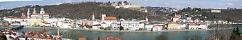
- Panoramic shots of the old town

The old town taken from the fortress Oberhaus . In the foreground the Danube , in the background the Inn
The old town and the Inn were taken from Mariahilf . In the background the Veste Oberhaus


Web links
- The old town on passau.de ( Memento from September 28, 2007 in the Internet Archive )
- Subdivision of the district into districts
- Map: historical structure of the center of Passau
Old town | Grubweg | Hacklberg | Haidenhof North | Haidenhof South | Neck | Heining | Downtown