Amer (river)
| Amer | ||
| Data | ||
| location | North Brabant , Netherlands | |
| River system | Rhine | |
| Drain over | Hollands Diep → Haringvliet (and Volkerak) → North Sea | |
| River basin district | Meuse | |
| origin | The Donge flows into the Bergsche Maas at Geertruidenberg 51 ° 42 ′ 49 ″ N , 4 ° 50 ′ 49 ″ E |
|
| muzzle | at location Zwaluwe in Hollands Diep coordinates: 51 ° 43 '14 " N , 4 ° 40' 41" E 51 ° 43 '14 " N , 4 ° 40' 41" E |
|
| Mouth height |
0 m
|
|
| length | 12 km | |
| Catchment area | 33,000 km² | |
| Drain |
MQ |
350 m³ / s |
| Residents in the catchment area | about 9 million | |
| Ports | Geertruidenberg | |
| Navigable | Draft 5.5 m | |
| lowest section of the Meuse | ||
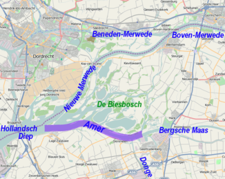
The Amer is the lowest section of the Meuse in the Netherlands , province of North Brabant .
It begins at Geertruidenberg at the confluence of the Donge with the artificial drainage path of the Maas to Hollands Diep , the so-called Bergse Maas , which was created in 1904 . The river section is about 12 kilometers long and forms the southern border of the De Biesbosch National Park .
Already 600 m after the Donge opposite, the Spijkerboor joins the Amer as the first arm of the Rhine, which is why the Rijkswaterstaat does not specifically classify it as the Meuse, but rather the Rhine-Maas estuary in South Holland . On the other hand, the Dutch kilometerage of the Meuse includes the Amer and ends at km 262 on the island Anna-Jacominaplaat at the confluence of the Amer and Nieuwe Merwede .
With this confluence, the Hollands Diep begins around 45 kilometers above the mouth of the southern arm of the Rhine into the sea at Haringvlietdam . If its locks are closed when the Rhine is low, the Meuse and Rhine flow into the North Sea exclusively (with the exception of the eastern arm of the Rhine IJssel ) via the Nieuwe Waterweg in Rotterdam. The water of the Meuse takes the way from the Hollands Diep to the Nieuwe Waterweg or its western part het Scheur through the Dordtsche Kil and the Oude Maas ( Old Maas ).
Drimmelen and Lage Zwaluwe are located on the Amer .
Individual evidence
- ↑ a b Marcel de Wit, Robert Leander, Adri Buishand: Extreme discharges in the Meuse basin ( Memento from January 6, 2014 in the Internet Archive ) (PDF file; 2.16 MB)
Web links
- Amer . In: rijkswaterstaat.nl . Rijkswaterstaat (Dutch)
