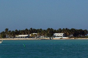
Anegada
| Anegada | ||
|---|---|---|
| View of the south side | ||
| Waters | Atlantic Ocean | |
| Archipelago | Virgin Islands | |
| Geographical location | 18 ° 43 '44 " N , 64 ° 20' 1" W | |
|
|
||
| surface | 39.32 km² | |
| Highest elevation | 8.5 m | |
| Residents | 285 (2010) 7.2 inhabitants / km² |
|
| main place | The settlement | |
| Map from 1832 | ||
Anegada (Spanish for "flooded") is the northernmost island of the British Virgin Islands , part of the Lesser Antilles in the Caribbean . It is the only coral island in the archipelago.
Anegada is flat; the highest point reaches a height of 8.5 m . The island with an area of about 39 km² is populated by almost 300 people. The largest settlement is called The Settlement.
The small airport is called Auguste George Airport . Ferries run three times a week.
Horseshoe reef
Anegada is known for its miles of white sandy beaches and for the Horseshoe Reef, with a length of 29 km the largest barrier reef in the Caribbean and one of the largest in the world. The reef makes seaward navigation difficult. Due to its countless shipwrecks , Horseshoe Reef used to be a popular diving spot; Anchoring in the reef is now prohibited for reasons of protection.
environment
A variety of animals such as turtles and lobsters live on the island, especially in the north .
The salt lakes in the west are a specialty. Resettled flamingos live there .
The vachellia anegadensis is for Anegada endemic acacia .
Web links
- Anegada. In: The British Virgin Islands. British Virgin Islands Tourist Board
- Anegada in the British Virgin Islands. In: British Virgin Islands. Bareboats BVI(English).
Individual evidence
- ^ Virgin Islands 2010 Population and Housing Census Report. (PDF; 2.52 MB) Executive Summary. Government of the Virgin Islands - Central Statistics Office, December 1, 2016, p. 1 , accessed December 28, 2017 .
- ^ Areas of the British Virgin Islands ( Memento of April 4, 2007 in the Internet Archive ); accessed on December 28, 2017.
- ^ Diving on Anegada. Horseshoe Reef on Anegada. In: Anegada, BVI. January 14, 2015, accessed December 28, 2017 .
- ↑ Navigating to Anegada. In: BVIPirate.com. Walker Mangum, accessed December 28, 2017 .


