Apple River (Mississippi River)
| Apple River | ||
|
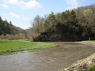
The Apple River in Apple River Canyon State Park |
||
| Data | ||
| Water code | US : 403579 | |
| location | Wisconsin , Illinois | |
| River system | Mississippi River | |
| Drain over | Mississippi → Gulf of Mexico | |
| source | East of Shullsburg in Lafayette County , Wisconsin 42 ° 33 ′ 51 ″ N , 90 ° 9 ′ 47 ″ W |
|
| muzzle | At Apple River Island northwest of Savanna in Carroll County , Illinois Coordinates: 42 ° 10 ′ 35 " N , 90 ° 14 ′ 36" W, 42 ° 10 ′ 35 " N , 90 ° 14 ′ 36" W |
|
| Mouth height |
179 m
|
|
| length | 89 km | |
| Left tributaries | South Fork Apple River | |
| Right tributaries | West Fork Apple River | |
The Apple River is a small left tributary of the Mississippi in southwestern Wisconsin and northwestern Illinois .
course
The Apple River rises in Lafayette County , Wisconsin . From there it flows south and after a few kilometers reaches the border with Jo Daviess County in Illinois . The river passes Apple River , which is about 2 km to the east. South of the village, the Apple River, the West Fork Apple River, is the largest right tributary. The South Fork Apple River flows further southeast . The direction of flow then gradually turns in a south-westerly direction. The river passes the northwestern edge of Elizabeth and reaches Hanover , which lies on both sides of the Apple River. In the further, mostly southern course, the river meanders more and more and reaches Carroll County . The river now forms the southeastern boundary of the former Savanna Army Depot , which is being converted into an industrial park. To the southwest of the small town of Blackhawk , the Apple River flows into the Mississippi at Apple River Island .
geology
The Apple River flows through the Driftless Area called the Ice Age-shaped plateau, which stretches across southeastern Minnesota , southwestern Wisconsin, northeastern Iowa, and far northwestern Illinois. During the last ice age, the so-called Wisconsin Glaciation , the region remained ice-free, so that the river valley of the Galena River was able to cut deeper into the plateau during this time.
To the south of Apple River, the river formed a deep cut into the plateau. This region has been designated Apple River Canyon State Park by the authorities of the state of Illinois .
Individual evidence
- ↑ USGS - Apple River. Retrieved April 11, 2012
- ↑ USGS The National Map Viewer. Retrieved April 11, 2012
- ↑ Illinois Department o Natural Resources - Apple River Canyon State Park ( Memento of the original from July 1, 2007 in the Internet Archive ) Info: The archive link was inserted automatically and has not yet been checked. Please check the original and archive link according to the instructions and then remove this notice. Retrieved April 11, 2012
