
Arrowtown
| Arrowtown | ||
| Geographical location | ||
|
||
| Coordinates | 44 ° 57 ′ S , 168 ° 50 ′ E | |
| Region ISO | NZ-OTA | |
| Country |
|
|
| region | Otago | |
| District | Queenstown-Lakes District | |
| Ward | Arrowtown Ward | |
| Local foundation | 1862 | |
| Residents | 2 445 (2013) | |
| height | 410 m | |
| Post Code | 9302 | |
| Telephone code | +64 (0) 3 | |
| UN / LOCODE | NZ ART | |
| website | www.arrowtown.com | |
| Photography of the place | ||
 historical Chinese settlement |
||

Arrowtown is a former gold rush town in the Otago regionon the South Island of New Zealand .
geography
Arrowtown is located at the end of the Arrow River valley , 17 km northeast of Queenstown . The place is surrounded in the north and east by mountains up to 929 m high, which are part of the Crown Range in the eastern area . The village is connected to the New Zealand State Highway 6 via the Arrow Junction settlement to the south .
population
The 2013 census counted 2445 inhabitants, which means an increase in the number of inhabitants by 13.7% compared to 2006.
history
Two years after the first European settlers established their farms in the Wakatipu region, the first gold was found near Arrowtown . In 1862, Jack Tewa , a sheep shearer , found gold in the Arrow River . The news quickly spread across the country and attracted numerous gold diggers . Within a few weeks, the place grew to around 1500 inhabitants. A year later, however, the town's gold mining suffered a severe setback when numerous gold prospectors were killed in the floods of a devastating flood. The city was subsequently rebuilt with more solid houses on the banks of the river. There were a total of 80 gold fields during the gold rush in Otago , which also included Arrowtown , but they disappeared again within a decade of their exploitation.
The so-called "Chinese settlement" was located on the western eastern edge of Arrowtown . By 1870, many Chinese came to the area looking for gold in the Arrow River and Shotover River gorges . Despite or because of their diligence, there was a lot of friction with the whites. Therefore, the Chinese had to live outside the settlement. Some small stone and adobe huts have now been restored.
During the height of the gold rush , Arrowtown's population rose to over 7,000. The bustling city became the center of a larger community that included the new towns of Macetown , Skippers and Bullendale (now ghost towns). After the gold rush, the population decreased rapidly.
From 1996 to 2001, the place experienced a population increase of over 18%, which triggered a new building boom in the city, but which is kept within limits by strict bans and restrictions in order to preserve the historical appearance.
tourism
Many old historic miner's houses, shops and restaurants have been restored for tourism in recent years. The former Bank of New Zealand building now houses a branch of the Lakes District Centennial Museum . The museum deals with the history of the areas around Lake Wakatipu , u. a. with the representation on the subject of gold mining. On the Arrow River you can try your luck panning for gold with pans borrowed .
The Cardrona BH fence is about 16 km northeast of the city .
Architectural monuments
The local Masonic Lodge, Arrow Kilwinning Lodge , has been recognized as a Historic Monument by the New Zealand Historic Places Trust . The remains of the Arrowtown Chinese Settlement from the times of the gold rush are also listed as historical monuments.
See also
photos

Historic pharmacy on Arrowtown's refurbished Main Street
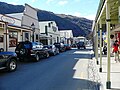
Main Street from Arrowtown

View of Arrowtown


literature
- Brian Newton Davis, Edward Stewart Dollimore: Arrowtown . In: Alexander Hare McLintock (Ed.): An Encyclopaedia of New Zealand . Wellington 1966 ( online [accessed May 19, 2017]).
Web links
- Homepage . Arrowtown Village Association,accessed May 19, 2017.
Individual evidence
- ↑ a b 2013 Census QuickStats about a place: Arrowtown . Statistics New Zealand , accessed May 19, 2017 .