Ashburton River (Indian Ocean)
| Ashburton River | ||
|
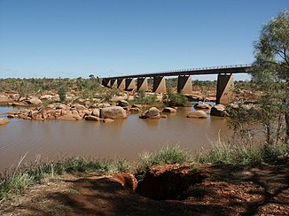
Ashburton River at Nanutarra |
||
| Data | ||
| location | Western Australia , Australia | |
| River system | Ashburton River | |
| Drain over | Ashburton River → Indian Ocean | |
| source | Bulloo Downs 23 ° 58 ′ 25 ″ S , 119 ° 49 ′ 0 ″ E |
|
| Source height | 724 m | |
| muzzle |
Indian Ocean at Onslow Coordinates: 21 ° 41 ′ 31 ″ S , 114 ° 54 ′ 55 ″ E 21 ° 41 ′ 31 ″ S , 114 ° 54 ′ 55 ″ E |
|
| Mouth height | 140 m | |
| Height difference | 584 m | |
| Bottom slope | 0.71 ‰ | |
| length | 825 km | |
| Catchment area | 66,850 km² | |
| Left tributaries | Monkey Creek, Brumby Creek, Ethel River , Turkey Creek, Glen Ross Creek, Gorge Creek, Mucalana Creek, Pingandy Creek, Little Pingandy Creek, Fords Creek, Wandarry Creek, Stockyard Creek, Gorge Creek, Irregully Creek, Sandy Creek, Henry River | |
| Right tributaries | Limestone Creek, Goldfields Creek, Perry Creek, Tunnel Creek, Angelo River , Turee Creek, Seven Mile Creek, Dead Horse Creek, Hardey River , Metawandy Creek, Duck Creek, Urandy Creek, Jubricoo Creek, Peepingee Creek | |
| Flowing lakes | Mooline Pool , Kooline Pool , Barliyunnu Pool , Cobbler Pool , Boolaloo Pool | |
| Communities | Bulloo Downs, Ashburton Downs, Kooline, Nanutarra Roadhouse, Nanutarra, Minderoo, Old Onslow Historic Ruin | |
The Ashburton River is a river in the northwest of the Australian state of Western Australia . It is located in the Pilbara region .
geography
The river has its source between Ophthalmia Range and Lofty Range at Bulloo Downs about 50 km south of Newman near the Great Northern Highway . It first flows west to Mount Vernon . There it turns to west-northwest and flows into the Indian Ocean about 20 km west of Onslow .
Tributaries with mouth heights
- Limestone Creek - 542 m
- Goldfields Creek - 502 m
- Monkey Creek - 485 m
- Brumby Creek - 422 m
- Perry Creek - 418 m
- Ethel River - 394 m
- Tunnel Creek - 387 m
- Turkey Creek - 379 m
- Glen Ross Creek - 366 m
- Gorge Creek - 347 m
- Mucalana Creek - 336 m
- Pingandy Creek - 322 m
- Little Pingandy Creek - 312 m
- Angelo River - 297 m
- Turee Creek - 268 m
- Fords Creek - 256 m
- Wandarry Creek - 245 m
- Seven Mile Creek - 243 meters
- Stockyard Creek - 221 m
- Gorge Creek - 215 m
- Dead Horse Creek - 199 m
- Irregully Creek - 182 m
- Hardey River - 140 m
- Metawandy Creek - 139 m
- Duck Creek - 123 m
- Urandy Creek - 115 m
- Sandy Creek - 98 m
- Henry River - 98 m
- Jubricoo Creek - 62 m
- Peepingee Creek - 46 m
Flowing lakes
- Mooline pool - 209 m
- Kooline Pool - 183 m
- Barliyunnu Pool - 126 m
- Cobbler Pool - 116 m
- Boolaloo Pool - 113 m
history
The town of Onslow was originally located at the estuary and a pier served as a port for the settlement and the region. After the construction of a deep water port at Beadon Point, about 15 km to the east, the residents relocated.
fauna
There are many species of fish in the Ashburton River, such as: B. the Barramundi and the Mangrove Jack ( Lutjanus argentimaculatus ). Occasionally one can also find saltwater crocodiles in the lower reaches. The banks populate mourning swans , scarlet macaw , Australian bustards and Buschtriele .
See also
Individual evidence
- ↑ a b c d e Map of Ashburton River, WA . Bonzle.com
- ↑ Ashburton River Basin . Waters and Rivers Commission. Government of Western Australia ( Memento of April 21, 2005 in the Internet Archive )
- ^ Steve Parish: Australian Touring Atlas. Steve Parish Publishing, Archerfield QLD 2007, ISBN 978-1-74193-232-4 , pp. 85 + 86.
- ↑ History of country town names - O ( English ) In: Landgate . Government of West Australia. 2007. Archived from the original on June 15, 2007. Retrieved on February 27, 2011.
- ^ Animals of Walkabout Creek . EP-A (2007) ( Memento of September 30, 2007 in the Internet Archive )
- ↑ http://www.abc.net.au/news/australia/wa/northwa/200606/s1652578.htm (link not available)
- ↑ Striated Heron . Bird Forum (2007)
