Ashdown, Arkansas
|
|
This article was on the basis of substantive defects quality assurance side of the project USA entered. Help bring the quality of this article to an acceptable level and take part in the discussion ! A closer description on the resolving issues is missing. |
| Ashdown | |
|---|---|
 Little River County's County Courthouse in Ashdown at Christmas time |
|
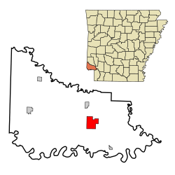
| Location of Ashdown in Little River County (bottom) and location of the county in Arkansas (top) | |
| Basic data | |
| Foundation : | June 11, 1892 |
| State : | United States |
| State : | Arkansas |
| County : | Little River County |
| Coordinates : | 33 ° 40 ′ N , 94 ° 8 ′ W |
| Time zone : | Central ( UTC − 6 / −5 ) |
| Residents : | 4,781 (as of: 2000) |
| Population density : | 259.8 inhabitants per km 2 |
| Area : | 18.5 km 2 (about 7 mi 2 ) of which 18.4 km 2 (about 7 mi 2 ) is land |
| Height : | 98 m |
| Postal code : | 71822 |
| Area code : | +1 870 |
| FIPS : | 05-02380 |
| GNIS ID : | 0076204 |
Ashdown is a small town and the county seat of Little River County in Arkansas . The total area of the place is 18.5 km². In an estimate from 2007, the place had 4,446 inhabitants.
Ashdown is part of the Ark-La-Tex socio-economic region that includes parts of the states of Arkansas, Louisiana , Oklahoma, and Texas .
Demographics
In the 2000 census, the place had 4,781 inhabitants, who were distributed among 1,880 households and 1,287 families. The population density was thus 259.6 inhabitants / km². 62.85% of the population were white and 34.09% were African American. Children under the age of 18 lived in 32.5% of households. The median income was $ 26,754 per household, with 18.9% of the population living below the poverty line .
| Population development | |||
|---|---|---|---|
| Census | Residents | ± in% | |
| 1900 | 400 | - | |
| 1910 | 1247 | 211.8% | |
| 1920 | 2052 | 64.6% | |
| 1930 | 1607 | -21.7% | |
| 1940 | 2332 | 45.1% | |
| 1950 | 2738 | 17.4% | |
| 1960 | 2725 | -0.5% | |
| 1970 | 3522 | 29.2% | |
| 1980 | 4218 | 19.8% | |
| 1990 | 5150 | 22.1% | |
| 2000 | 4781 | -7.2% | |
| 1900-2000 | |||
history
Little River County was formed from areas of Sevier and Hempstead Counties in 1867. In 1906, the county seat was moved from Foreman to Ashdown. In 1907 a new courthouse was built. In 1912 there was a railway connection. That was followed by electricity and telephone. Ashdon suffered from the Great Depression and several farmers were forced to sell their land in the 1930s.
Web links
- Website of the City Ashdown (Engl.)
- City profile on arkansas.com (Engl.)
Individual evidence
- ↑ US-Census Bureau (English)
- ^ Extract from the Encyclopedia of Arkansas . Retrieved February 13, 2011

