
Aubach (Sendelbach)
|
Aubach Old name: Aubächel |
||
 View upstream of the mouth of the Finsterweihergraben (from the right behind) into the Aubach (from the left behind) |
||
| Data | ||
| location | Germany | |
| River system | Rhine | |
| Drain over | Sendelbach → Mistel → Roter Main → Main → Rhine → North Sea | |
| source | approx. 0.8 km southeast of the Rödendorf district at the northeast foot of the Sophienberg in Bayreuth 49 ° 53 ′ 31 ″ N , 11 ° 33 ′ 37 ″ E |
|
| Source height | approx. 495 m above sea level NN | |
| muzzle | 400 m below the Röhrensee from the left in the Sendelbach Coordinates: 49 ° 56 '15 " N , 11 ° 34' 35" E 49 ° 56 '15 " N , 11 ° 34' 35" E |
|
| Mouth height | approx. 340 m above sea level NN | |
| Height difference | approx. 155 m | |
| Bottom slope | approx. 22 ‰ | |
| length | around 7.2 km | |
| Catchment area | 8.8 km² | |
The Aubach is a brook in Upper Franconia in the river systems of Mistletoe and Red Main , which flows into the Sendelbach from the left and south in Bayreuth .
Surname
The Aubach must not be confused with the upper reaches of the Tappert , which is also called Aubach in the neighboring towns from its source area to Thiergarten .
The Aubach is referred to as the Aubächel on a map from the 19th century .
geography
course


The Aubach rises in the south of the city of Bayreuth not far from the district Rödensdorf at the northeast foot of the Sophienberg at about 495 m above sea level. NN . It initially flows in a north-easterly direction and reaches today's urban area just below the source. The development of the Destuben district avoids the valley location because of the risk of flooding in spring, but the stream there only carries sparse water in summer. East of Destuben was 2017 to near Tappert About conductor applied. In the event of a flood, water can flow through it to its retention basin near Oberkonnersreuth .
In Karolinenreuth, the Aubach receives more water from an artificial pond in summer than it carries itself. At the Hohlmühle district, it turns to the northwest, here too water comes from a pond drain. In the past, he largely crossed under the adjoining area of the former parade ground south of the allotments of the same name in a closed canal. Apart from the street underpasses, this is open again and the stream in this area has been renatured. The two sandstone canal openings south of Universitätsstrasse and later west of Schwedenbrücke were preserved. The stream runs here for a short stretch from south to north in the ecological-botanical garden and flows into a backwater basin. From this it flows to the north-west, leaves the fenced area and runs along the allotment garden area “Parade ground” on the right bank through a meadow. Behind the old canal mouth, it crosses the gardens of the allotment garden “Schwedenbrücke” in a paved bed, after which it feeds another pond with a branch.
At the confluence of the Finsterweihergraben , which tapers from the south, it swings to the north and flows in the Röhrenseepark through the "C'est-bon-Tal" into the long Röhrensee . This approximately 1⅔ hectare reservoir, fed by the Aubach, is the largest standing body of water in the city. The Rohrweiher , one of its two predecessors, can be traced back to 1611 as a warehouse for wooden water pipes (" dykes "). Today the lake with its surrounding park, a boat rental, freely accessible animal enclosures, a beer garden and a large "cross-generational play area" is a popular local recreation area.
At the northern end it runs over a weir from the Röhrensee and initially flows a good 300 meters in an open direction, accompanied by a tree gallery, northeast. Shortly before the Wittelsbacherring, it disappears into an underground inlet nozzle and flows into it less than 100 meters further on the other side of the street from the left into the Sendelbach , which has been running in a closed canal here since the Wittelsbacherring was built.
Catchment area
The catchment area of the Aubach is about 8.8 km². Its southern tip with a little over 590 m above sea level. The highest point reaching the NHN is on the Sophienberg, its northern tip almost 6 km away at the mouth in Bayreuth; in between it widens like a kite to a width of about 3 km.
A small area around the southern tip is just in the Black Jura , after a narrow transition zone in the Feuerletten ( Trossingen Formation ), which runs close to the southwestern watershed, the vast majority of the catchment area is in the Sandstone Keuper . A fault runs along the Lias-Keuper border.

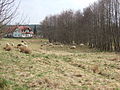
Aubach near Destuben - the Tappert runs in the forest in the background
Aubachsenke near Karolinenreuth

Beginning of the Aubach tube on Universitätsstrasse

Renatured (formerly piped) run in the ecological-botanical garden

Backwater basin in the Ecological Botanical Garden

Old canal mouth at the Schwedenbrücke
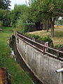
Concreted run in the allotment gardens Schwedenbrücke

Inflow from the Oberer Quellhof on the slope of the C'est-bon valley
Road and former railway bridge in Röhrenseepark

Weir at the outlet of the Röhrensee

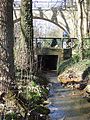
Passage under Hegelstrasse

Aubachende at Wittelsbacherring


Others
In the summer of 2019, some sections of the Aubach no longer had water due to the persistent drought.
See also
- List of flowing waters in the mistletoe river system - comprehensive river system
literature
- Kurt Herterich: Southern Bayreuth . Ellwanger, Bayreuth 1996, ISBN 978-3-925361-26-5 .
- Herbert Popp: Bayreuth - rediscovered . Ellwanger, Bayreuth 2007, ISBN 978-3-925361-60-9 .
Individual evidence
- ↑ Catchment area roughly measured on: BayernAtlas of the Bavarian State Government ( information )
- ^ Herbert Popp: Bayreuth - newly discovered, p. 65.
- ^ Silent reserve for still waters in: Nordbayerischer Kurier of April 5, 2017, p. 10.
- ↑ Kurt Herterich : Südliches Bayreuth, p. 72.
- ↑ Kurt Herterich: Südliches Bayreuth, p. 85.
- ↑ Geology based on the geological map of Bavaria 1: 500,000 layer on: Bavaria Atlas of the Bavarian State Government ( references )
- ↑ Extreme drought causes brooks to dry up in: Nordbayerischer Kurier, September 3, 2019, p. 17.