Auriac-de-Bourzac
| Auriac-de-Bourzac | ||
|---|---|---|
|
|
||
| local community | Nanteuil-Auriac-de-Bourzac | |
| region | Nouvelle-Aquitaine | |
| Department | Dordogne | |
| Arrondissement | Périgueux | |
| Coordinates | 45 ° 22 ′ N , 0 ° 16 ′ E | |
| Post Code | 24200 | |
| Former INSEE code | 24017 | |
| Incorporation | 1st January 1973 | |
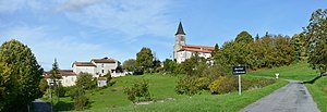
 View of Auriac-de-Bourzac |
||
Auriac-de-Bourzac is a village and a former French commune with the last 157 inhabitants (1968) in the department of Dordogne in the region Nouvelle-Aquitaine (before 2016: Aquitaine ).
On January 1, 1973, the municipality was incorporated into the municipality of Nanteuil-de-Bourzac, which from then on bears the name Nanteuil-Auriac-de-Bourzac .
The name in the Occitan language is Auriac de Borzac . The two parts of the name are derived from the names of the owners "Aureus" or "Bursius" or "Burtius" of estates in Gallo-Roman times .
geography
Auriac-de-Bourzac is located approx. 45 km northwest of Périgueux in the Ribéracois region of the historic province of Périgord on the western border with the neighboring Charente department .
Toponymy
Toponyms and mentions of Auriac-de-Bourzac were:
- Auriac (church register),
- Auriacum (1365, font collection of the Abbé de Lespine),
- Auriac (1750, 1793 and 1801, map from Cassini , Notice Communale or Bulletin des Lois ),
- Auriac-de-Bourzac (1873, Dictionnaire topographique du département de la Dordogne).
Population development
After the beginning of the records, the population rose to a high of around 510 by the middle of the 19th century. In the period that followed, the population fell to 157 inhabitants during short recovery phases until the incorporation.

Source: EHESS / Cassini
Web links
Individual evidence
- ↑ a b c Notice Communale Auriac-de-Bourzac ( fr ) EHESS . Retrieved November 9, 2018.
- ↑ Le nom occitan des communes du Périgord ( fr ) Départementrat des Dordogne. Retrieved November 9, 2018.
- ^ Nanteuil-Auriac-de-Bourzac ( fr ) Conseil régional d'Aquitaine. Archived from the original on January 21, 2016. Retrieved November 9, 2018.
- ^ Paul Vicomte de Gourgues: Dictionnaire topographique du département de la Dordogne ( fr ) In: Dictionnaire topographique de la France . Imprimerie nationale. S. 8, 1873. Retrieved November 9, 2018.
- ^ France 1750 ( en ) David Rumsey Map Collection: Cartography Associates. Retrieved November 9, 2018.
