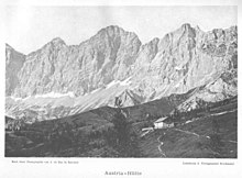
Austriahütte
| Austriahütte ÖAV hut category II |
||
|---|---|---|
|
against Rötelstein and Bischofsmütze |
||
| location | on the Brandalm, south of the Hohe Dachstein ; Liezen District , State of Styria , Austria ; Valley location: Ramsau am Dachstein | |
| Mountain range | Dachstein Mountains | |
| Geographical location: | 47 ° 26 '34 " N , 13 ° 37' 7" E | |
| Altitude | 1638 m above sea level A. | |
|
|
||
| owner | Alpine Association Austria of the PES | |
| Built | 1880 | |
| Construction type | hut | |
| Usual opening times | Mid-May to the end of October and Christmas to Easter | |
| accommodation | 33 beds, 26 camps | |
| Web link | Austriahütte | |
| Hut directory | ÖAV DAV | |
The Austriahütte is an alpine club hut of the Alpenverein Austria section of the PES at an altitude of 1638 m on the Brandalm south of the Hohe Dachstein , the south face of which towers impressively from here. It is the oldest refuge on the Dachstein. Politically, it belongs to the municipality of Ramsau in the Austrian state of Styria . Due to its easy accessibility, the Austriahütte is a popular destination for hikers. It is less important for mountaineers , who can take longer tours on the Dachstein from here, but can also shorten the arduous ascent with the nearby Dachsteinsüdwandbahn (a cable car ).
history
The hut was built in 1880 as one of the first shelters in the Dachstein Mountains by the “ Austrian Section ”. Due to the large number of visitors, it had to be expanded as early as 1887. The location on the Brandalm was chosen because the hut offers a good view of the well-known south face of the Dachstein and the Bischofsmütze and also the Niederen and Hohe Tauern . In 1932 a new building was built, and since its completion the house has been managed all year round and is often used as a holiday and ski home. Today the Dachstein Alpine Museum is housed in several rooms .
Accesses
- From the Türlwandhütte ( 1700 m , parking lot, via toll road) on the Höhenweg, walking time: 30 minutes
- From Ramsau am Dachstein via Edelbrunn and Brandriedel, easy, walking time: 1.5 hours
Transitions
- Dachstein Südwandhütte ( 1871 m ) via Türlwandhütte , easy, walking time: 1.25 hours
- Seethalerhütte ( 2740 m ) via Südwandhütte, Hunerscharte and Glacier Trail , easy, walking time: 4.5 hours
- Simonyhütte ( 2205 m ) via Südwandhütte, Hunerscharte and Hallstätter Glacier , medium, walking time: 5 hours
- Guttenberghaus ( 2146 m ) via Edelgriessscharte and Ramsauer Höhenweg , medium, walking time: 5 hours
- Guttenberghaus via Edelgriessscharte and Ramsau via ferrata, difficult, walking time: 6 hours
Mountaineering
- Brandriedel ( 1725 m ), easy hut summit, walking time: 20 minutes
- Großer Koppenkarstein ( 2865 m ) via Edelgrieß, Walchersteig, Austriascharte and Westgrat via ferrata, only for experienced, walking time: 4 hours
- High Gjaidstein ( 2794 m ) via Südwandhütte, Hunerscharte and Gjaidsteinsattel, medium, walking time: 4.5 hours
- Raucheck ( 2192 m ) via Südwandhütte, Pernerweg, Tor and north flank, medium, walking time: 3.5 hours
cards
- Alpine Club map sheet 14 Dachstein (1: 25,000)
Web links
- Austriahütte
- Alpenverein.at: Austriahütte
Individual evidence
- ↑ DAV-Shop - Item details - 14 Dachstein -. Retrieved October 5, 2019 .


