
Bishop's cap
| Big bishop's cap | ||
|---|---|---|
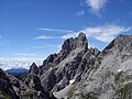
 View from the southeast (March 2017) |
||
| height | 2458 m above sea level A. | |
| location | Salzburg , Austria | |
| Mountains | Gosaukamm , Dachstein Mountains | |
| Dominance | 4.9 km → Eiskarlspitz | |
| Notch height | 612 m ↓ leakage saddle | |
| Coordinates | 47 ° 29 '38 " N , 13 ° 30' 40" E | |
|
||
| rock | Summit structure made of Dachstein reef limestone ; Base made of rocks from the main dolomite | |
| Age of the rock | Upper Triassic | |
| First ascent | June 28, 1879 Johann Anhäusler and Johann Steiner | |
| Normal way | Cap Gorge ( III + ) | |

The Große Bischofsmütze is with a height of 2458 m above sea level. A. the highest peak in the Gosaukamm of the Dachstein massif . Together with the Kleiner Bischofsmütze ( 2430 m above sea level ) it forms a striking double peak that rises freely from the Gosaukamm. The Bischofsmützen are separated from each other by the Mützenschlucht and are located on the border between the municipalities of Filzmoos and Annaberg-Lungötz .
history
It takes its name from the characteristic double-peaked shape. Historically, the name Gosauer Stein can also be found because it stands above the Gosau valley . 'Bischofsmütze' also refers to the fact that it formed the border between the Archduchy of Austria and the Archbishopric of Salzburg , and that it “kept watch” over the Ennspongau of the Salzburg Archbishop.
It was first raised by Johann Schrempf (= Auhäusler) and Johann Steiner on June 28, 1879.
The famous landmark lost a 200 m high pillar in a massive landslide on September 22, 1993, and thus lost a lot of its striking appearance. Since then, there have been repeated falls, like in 1999 and 2001.

The Bischofsmütze before (1980) ...
... and after (2010) the rock falls of 1993


Climb
Since many climbing routes (some of which are bolted ) lead to the Bischofsmütze, it is very popular with climbers. Before the rock falls, around 30 routes led to the summit, now there are 15.
The via ferrata is closed until further notice due to the threat of a rock fall.
The Hofpürglhütte serves as the nearby starting point . The normal route to both peaks leads through the Mützenschlucht from the south ( UIAA scale II +, one point III ).
Others
On March 22, 1974, the Austrian Post issued a definitive stamp of the series Landscapes from Austria for this motif for 3.00 Schilling.
Views

Bischofsmütze, view from the northeast (2001)

West view (2009)

from the southwest (July 1993, before the landslide)

View from the south (January 2008)

.jpg)


Web links
Individual evidence
- ^ Christian Leidinger: Geology of the Dachstein area ( Memento from August 18, 2010 in the Internet Archive ); Retrieved February 3, 2011.
- ↑ Bruckmanns summit Atlas Alps, Eugene W. Hüsler, Munich 2004
- ↑ The Salzburg Limestone Alps . In: Meyers Großes Konversations-Lexikon . 6th edition. Volume 1, Bibliographical Institute, Leipzig / Vienna 1905, p. 361 . - The Salzburg Limestone Alps
- ↑ Kurt Maix: Under the spell of the Dachstein south face . 8th edition. The Bergland Book, Salzburg / Stuttgart 1969, p. 370 .
- ^ Warning of rockslide on Bischofsmütze. In: Orf.at . July 25, 2019, accessed September 17, 2019 .