
Büelenhorn (Davos)
| Büelenhorn | ||
|---|---|---|
 Davos Dorf with the Büelenhorn in the background |
||
| height | 2513 m above sea level M. | |
| location | Canton of Graubünden , Switzerland | |
| Mountains | Albula Alps | |
| Dominance | 0.51 km → Baslersch Chopf | |
| Notch height | 27 m ↓ Scharte between Büelenhorn and Baslersch Chopf | |
| Coordinates | 786 978 / 185360 | |
|
||
.jpg) Steinmann on the Büelenhorn |
||

The Büelenhorn (plural for Swiss German Büel, Bühl for 'hill', 'hill') is a mountain southeast of Davos Dorf in the canton of Graubünden in Switzerland with a height of 2513 m above sea level. M. From the Büelenhorn you have a good view of the Parsenn ski area and the Landwassertal . In order to avoid confusion with the Monsteiner Büelenhorn , locals sometimes refer the place name Büelenberg to the summit. Correctly, however, only the northwest ridge of the Büelenhorn is called Büelenberg.
Location and surroundings
The Büelenhorn belongs to the Schwarzhorn chain, a subgroup of the Albula Alps . The summit is located entirely within the municipality of Davos . It is bordered in the north and east by the Flüela valley and in the south and west by the Dischma .
The neighboring peak is the Baslersch Chopf in the southeast. The valley location is Davos Dorf.
Routes to the summit
Summer routes
Over the western slope
- Starting point: Hof ( 1663 m ) in Dischma
- Via: Am Berg ( 1873 m ) or Lucksch Alp ( 1870 m )
- Difficulty: B
- Time required: 2½ hours
Over the northwest ridge
- Starting point: Davos Dorf ( 1560 m )
- Via: Alp Inschlag ( 1837 m ), Büelenberg ( 2117 m )
- Difficulty: B until Büelenberg as trail white-red-white highlighted
- Time required: 3 hours
Over the northeast slope
- Starting point: Gasthaus Alpenrose ( 1820 m ) in the Flüela valley
- Via: Schindelboden ( 1803 m ), P. 1822, Blackbirds, Südostkamm
- Difficulty: EB
- Time required: 2¼ hours
Winter routes
From Davos Dorf
- Starting point: Duchlisage Davos Dorf ( 1563 m )
- Via: In den Büelen, Alp Ischlag ( 1838 m ), Büelenberg ( 2117 m )
- Exposures: SW, NW
- Difficulty: WS
- Time required: 3 hours
Departure to Dischma
- Destination: Hof ( 1663 m ) in Dischma
- Via: Gletti, Am Berg
- Exposures: SW
- Difficulty: ZS
panorama
_Panorama.jpg)
gallery
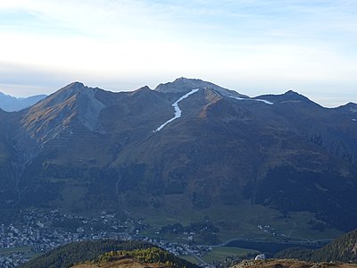
View of the Parsenn area , two snow-covered slopes visible .
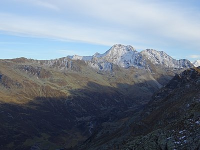
View to the southeast to the Flüela Wisshorn .
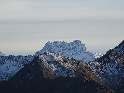
View to the south to Piz Kesch .
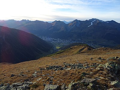
View down to Davos .

View into the Flüela valley to the valley station of the Pischa ski area and the Gasthof Alpenrose.
.jpg)
.jpg)
.jpg)
.jpg)
.jpg)
literature
- Manfred Hunziker: Club guide, Bündner Alps . From the Septimer to the Flüela. 3. Edition. Vi. Verlag des SAC, 2000, ISBN 3-85902-187-7 , p. 398-399 .
- Vital Eggenberger: Ski tours Graubünden South . Verlag des SAC, 2010, ISBN 978-3-85902-301-7 , pp. 206-207 .
- National map of Switzerland, sheet 1197 Davos, 1: 25,000, Federal Office of Topography, 2014 edition.
Web links
Individual evidence
- ↑ Andrea Schorta: How the mountain got its name . Small Rhaetian name book with two and a half thousand geographical names of Graubünden. Terra Grischuna Verlag, Chur and Bottmingen / Basel 1988, ISBN 3-7298-1047-2 , p. 70 .
- ^ Manfred Hunziker: Club guide, Bündner Alps . From the Septimer to the Flüela. 3. Edition. Vi. Verlag des SAC, 2000, ISBN 3-85902-187-7 , p. 398 .
- ↑ Vital Eggenberger: Ski tours Graubünden South . Verlag des SAC, 2010, ISBN 978-3-85902-301-7 , pp. 206 .