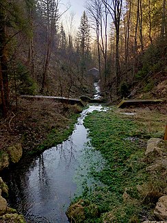
Bachrunzelbach
| Bachrunzelbach | ||
| Data | ||
| Water code | DE : 125932 | |
| location |
Bavaria
|
|
| River system | Lech | |
| Drain over | Lech → Danube → Black Sea | |
| source | Dead ice kettle 0.5 km west of Reichlingsried 47 ° 56 ′ 1 ″ N , 10 ° 55 ′ 58 ″ E |
|
| Source height | 724 m above sea level NHN | |
| muzzle | about 0.8 km west-north-west of Apfeldorfhausen from the right in the Lech coordinates: 47 ° 54 '29 " N , 10 ° 55' 55" E 47 ° 54 '29 " N , 10 ° 55' 55" E |
|
| Mouth height | 635 m above sea level NHN | |
| Height difference | 89 m | |
| Bottom slope | 20 ‰ | |
| length | 4.6 km | |
| Catchment area | 9.26 km² | |
The Bachrunzelbach is a 4.6 km long right tributary of the Lech in the Landsberg am Lech district in Upper Bavaria .
course
The Bachrunzelbach rises about 500 meters west of Reichling Ried in a Toteiskessel .
The stream initially flows south-east and past Reichlingsried before it finally flows in a sharp bend to the south-west.
After it has crossed the road from Reichling to Rott , it flows through a valley that cuts deeper and deeper.
The brook passes the Bachrunzel farmstead, shortly before the mouth, the gorge is almost 70 m deep.
Finally, the Bachrunzelbach flows from the right into the Lech reservoir of Lech barrage 10 - Epfach at 635 m above sea level. NHN .
The 4.6 km long Bachrunzelbach flows about 89 meters below its origin and thus has an average bed gradient of about 20 ‰.
Individual evidence
- ^ BayernAtlas. Accessed January 30, 2019 .
