Bachta (river)
|
Bachta Бахта́ |
||
| Data | ||
| Water code | RU : 17010600112116100054087 | |
| location | Krasnoyarsk Region ( Russia ) | |
| River system | Yenisei | |
| Drain over | Yenisei → Arctic Ocean | |
| source |
Central Siberian Mountains 62 ° 55 ′ 54 ″ N , 93 ° 26 ′ 31 ″ E |
|
| Source height | approx. 630 m | |
| muzzle | near Bachta in the Yenisei Coordinates: 62 ° 27 '55 " N , 89 ° 0' 1" E 62 ° 27 '55 " N , 89 ° 0' 1" E |
|
| Mouth height | 19 m | |
| Height difference | approx. 611 m | |
| Bottom slope | approx. 1.2 ‰ | |
| length | 498 km | |
| Catchment area | 35,500 km² | |
| Drain |
MQ |
270 m³ / s |
| Left tributaries | Tynep , Suchaja Bachta | |
| Right tributaries | Goldoikta , Maigunna , Suringdakon , Tanatschi , Deltula , Churingda | |
| Communities | Bakhta | |
| Navigable | in the lower reaches | |
|
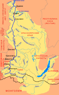
Location of the Bachta (Бахта́) in the catchment area of the Yenisei |
||
The Bachta ( Russian Бахта́ ) is a right tributary of the Yenisei in the Krasnoyarsk region in Siberia .
The Bachta rises in the west of the Central Siberian Mountains . It initially runs predominantly in a north-westerly direction, then in the lower reaches in a south-south-west direction. After 498 km the Bachta flows into the Yenisei on the right near the settlement of the same name . The 35,500 km² catchment area of the Bachta extends between the Lower Tunguska , which runs north, and the Stony Tunguska, which runs south . The river is usually covered with ice between mid-October and mid-May. The lower course of the Bachta is navigable.
Individual evidence
- ↑ Soviet General Staff Map 1: 200,000. Sheet P-46-IX, X. Edition 1987
- ↑ Soviet General Staff Map 1: 200,000. Sheet P-45-XVII, XVIII. Edition 1989
- ↑ a b c d Article Bachta (river) in the Great Soviet Encyclopedia (BSE) , 3rd edition 1969–1978 (Russian)
- ↑ a b Bachta in the State Water Register of the Russian Federation (Russian)

