
Châtelet - Les Halles train station
| Châtelet - Les Halles | |
|---|---|
 |
|
| Data | |
| Location in the network | Crossing station |
| Design |
Through station tunnel station |
| Platform tracks | 7th |
| opening | December 9, 1977 |
| location | |
| City / municipality | Paris |
| Place / district | 1st arrondissement |
| Department | Paris |
| region | Île-de-France |
| Country | France |
| Coordinates | 48 ° 51 '41 " N , 2 ° 20' 47" E |
| Railway lines | |
| List of train stations in France | |
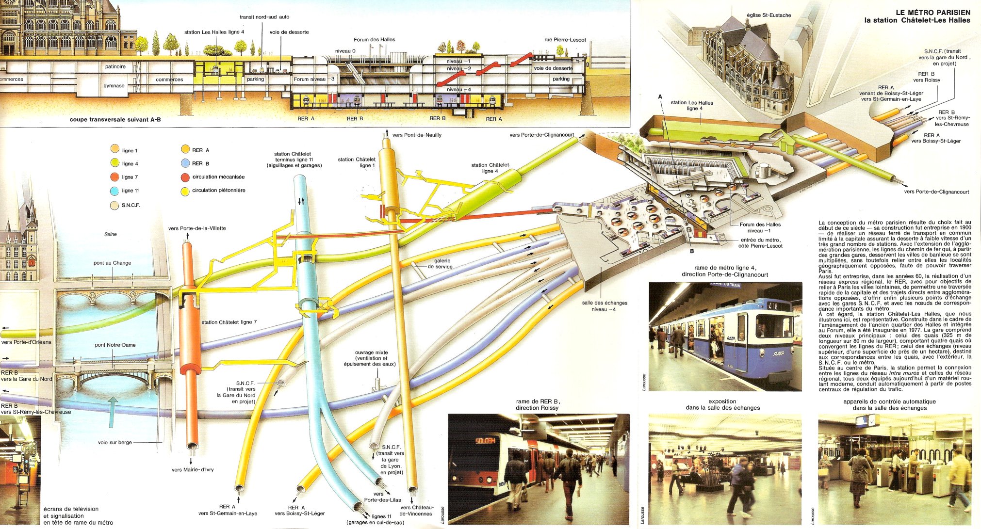
The Gare de Châtelet - Les Halles is a 1977 Opened Tunnel railway station in the center of the French capital Paris . He is from the lines A , B and D of the S-Bahn -like Réseau express régional (RER) operated and offers interchanges to five metro lines . With seven parallel platform tracks , it is one of the largest underground train stations in the world. The station is used by around 750,000 passengers every day.
location

The station is located in the northern half of the city Rive Droite in the Quartier des Halles of the 1st arrondissement . It is located under the Forum des Halles shopping center between Rue Rambuteau and Rue Sainte-Honoré. In the south it borders on the Châtelet transfer station of the Métro, at the north end it passes under its Les Halles station .
Surname
The composite name arises from the two adjacent metro stations , with which it is directly connected for transfer passengers .
Name-giving for the subway station of the underground lines 1 , 4 , 7 , 11 and 14 is the Place du Châtelet . The Grand Châtelet castle, built on the site in 1130, secured the Grand Pont bridge (today: Pont au Change ), the river crossing from the northern bank of the Seine to the Île de la Cité . After the construction of the city wall, the building became the official residence of Prévôt de Paris in the 13th century and served a. a. as a court and prison. In 1802 it was demolished on the orders of Napoleon Bonaparte .
The former market halls Halles de Paris gave the name to the station Les Halles of Métrolinie 4. The location was created as a public marketplace in 1135, and permanent buildings were added in 1183. From 1850 to 1856 ten steel halls were built, which were demolished between 1971 and 1974 after the wholesale market was relocated to Rungis .
history

The operator of the Métro, the Régie autonome des transports Parisiens (RATP), was responsible for the beginnings of the RER network; the state railway SNCF only joined in with its later expansion . Unlike the Métro, the traffic is carried out with electric multiple units , which get their power from an overhead line . Châtelet-Les Halles train station is electrified with a direct voltage of 1500 V.
On December 12, 1969, the first section of the RER line A in the east of the city went into operation, on February 20, 1970 another in the west of Paris. The gap under the city center, and with it the opening of the Châtelet-Les Halles station, took place on December 9, 1977. At the same time, the first section of line B, with Châtelet-Les Halles as the northern end point, was put into operation. In 1981, line B was extended to Gare du Nord long-distance train station .
According to the original plan, the RER line D was to use the tracks of line B from Gare du Nord to Châtelet-Les Halles and change from there to line A in the direction of Gare de Lyon . Operations on the B line to Châtelet-Les Halles began on September 27, 1987 and still exists. However, the continuation via the A route was rejected because it was already fully utilized. Since September 24, 1995, line D has been using a separate tunnel to the Gare de Lyon, making Châtelet-Les Halles a through station for them too .
description


The underground station hall is on level -5, it is 325 m long, 80 m wide and has seven tracks on four platforms. Above this is the distribution floor on level -4, from which the Métro stations can be reached, partly via moving walks .
Unlike the Métro, the RER trains run on the left. The names for the tracks are from east to west 1A, 1B, 3, Z, 4, 2B, 2A, those of platforms 1, 3, 4, 2. Platforms 1 and 2 are approached in directional operation , there you can move between the lines A and B can be transferred on the same level. The trains on line C stopped on tracks 3 and 4 at the outer edges of the middle platforms 3 and 4 until 2013. Between them is track Z, which was initially used for turning trains on line D (e.g. also from 2008 to 2013 ) was used. It is now used as track 4Z in regular traffic on this line in a south-north direction with the advantage of faster passenger changes (“ Spanish solution ”). In the opposite direction, the D-trains continue to stop on track 3.
Passenger volume
In 2009 around 750,000 passengers used the transfer complex every day, 493,000 of them for the RER lines. This makes it one of the most important transfer stations in the world.
future
The confusing and confusing tangle of the station complex, which is confusing and confusing for tourists and Parisians alike, has been a topic of discussion since its construction. The aim is to remedy this situation in the short term by building new escalators and improving the lighting. The future Sainte-Honoré exit will provide direct access to the RER trains from Rue des Halles and Rue de Rivoli.
Web links
Individual evidence
- ^ A b c Christoph Groneck: Metros in France . Robert Schwandl, Berlin 2006, ISBN 3-936573-13-1 , p. 72 ff .
- ^ Gérard Roland: Stations de métro d'Abbesses à Wagram . Christine Bonneton, Clermont-Ferrand 2011, ISBN 978-2-86253-382-7 , pp. 80 .
- ↑ Gérard Roland: Stations de métro d'Abbesses à Wagram , p. 130 f.
- ^ Jean Tricoire: La genèse du RER . In: Le Train spécial . Paris et l'Île-de-Françe, No. 37 , 2004, p. 22nd ff .
- ↑ Scheme and cross-section at grandparis.free.fr, accessed on March 26, 2019
- ↑ La ligne D de A à Z at sadur.org, accessed on March 26, 2019
- ↑ http://www.ratp.fr/common/ressources/concertation_p1.pdf ( Memento from March 18, 2009 in the Internet Archive )