Épernay – Reims railway line
| Charleville-Épernay-Reims | |||||||||||||||||||||||||||||||||||||||||||||||||||||||||||||||||||||||||||||||||||||||||||||||||||||||||
|---|---|---|---|---|---|---|---|---|---|---|---|---|---|---|---|---|---|---|---|---|---|---|---|---|---|---|---|---|---|---|---|---|---|---|---|---|---|---|---|---|---|---|---|---|---|---|---|---|---|---|---|---|---|---|---|---|---|---|---|---|---|---|---|---|---|---|---|---|---|---|---|---|---|---|---|---|---|---|---|---|---|---|---|---|---|---|---|---|---|---|---|---|---|---|---|---|---|---|---|---|---|---|---|---|---|
|
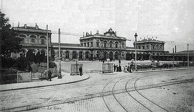
Reims train station with tram tracks in the foreground, 1910s.
| |||||||||||||||||||||||||||||||||||||||||||||||||||||||||||||||||||||||||||||||||||||||||||||||||||||||||
| Route number (SNCF) : | 074 000 | ||||||||||||||||||||||||||||||||||||||||||||||||||||||||||||||||||||||||||||||||||||||||||||||||||||||||
| Course book route (SNCF) : | 19 of the Région Est | ||||||||||||||||||||||||||||||||||||||||||||||||||||||||||||||||||||||||||||||||||||||||||||||||||||||||
| Route length: | 30.5 km | ||||||||||||||||||||||||||||||||||||||||||||||||||||||||||||||||||||||||||||||||||||||||||||||||||||||||
| Gauge : | 1435 mm ( standard gauge ) | ||||||||||||||||||||||||||||||||||||||||||||||||||||||||||||||||||||||||||||||||||||||||||||||||||||||||
| Power system : | 25 kV 50 Hz ~ | ||||||||||||||||||||||||||||||||||||||||||||||||||||||||||||||||||||||||||||||||||||||||||||||||||||||||
| Maximum slope : | 9 ‰ | ||||||||||||||||||||||||||||||||||||||||||||||||||||||||||||||||||||||||||||||||||||||||||||||||||||||||
| Top speed: | 40 km / h | ||||||||||||||||||||||||||||||||||||||||||||||||||||||||||||||||||||||||||||||||||||||||||||||||||||||||
| Dual track : | partially | ||||||||||||||||||||||||||||||||||||||||||||||||||||||||||||||||||||||||||||||||||||||||||||||||||||||||
|
|||||||||||||||||||||||||||||||||||||||||||||||||||||||||||||||||||||||||||||||||||||||||||||||||||||||||
The Épernay – Reims railway is a 30 km electrified railway line in northern France. For many years it was an important part of international rail passenger transport , today it is only of regional importance. The route connects the two arrondissement capitals of Épernay with Reims in the north .
history
The construction of this line went hand in hand with the realization of the Paris – Strasbourg railway , which reached Épernay at the end of August 1849 and branched off from it. The concession for both lines was at the Chemin de fer de l'Est . Even if the route is only 30 km long, there were still immense difficulties to contend with: At the eastern exit of Épernay the Marne had to be relocated and canalized and before Reims between Germaine and Rilly-la-Montagne a mountain had to be tunneled under for three and a half kilometers which cost eleven lives to build. The construction costs for the tunnel were 2.75 million francs.
The line opened in 1854 was initially the shortest route from Paris to Reims, but the opening of the Trilport – Bazoches line in 1894 saved 17 km and corresponding travel times. So the traffic shifted to the newer connection and the line Épernay – Reims only had a local function. But this was to change again at the end of the 1950s.
During the Franco-Prussian War , the tunnel was also the scene of fighting: French troops mined the north entrance. The restoration took more than a year after the war. During the First World War , the bridge over the Marne was destroyed while a troop transport was on its way to the front. This bridge was again the target of destruction in 1942. In addition, both tunnel entrances were made impassable during World War II . In the summer of 1943, one of the two tracks was also expanded by the German troops. The tunnel was also used for the production of the so-called Fieseler Fi 103 retaliatory weapon . In July 1944, 12 people were killed in targeted bombing by the Allies. Since June 2009 a stele has stood near the southern tunnel portal in Germaine, commemorating the bomb damage of July 17 and 31, 1944. The restoration lasted until 1947.
With the electrification of the Paris – Strasbourg line as part of the Est-Paris measure at the end of the 1950s, this line was also electrified. In 1960/61, further modernization measures were carried out on the line. This included switching to BAL signaling and increasing the speed on the two-lane sections to 100 to 120 km / h. The marshals were disbanded in January 1962 and the controls were put into operation centrally from Reims. With this upgrade, the railway regained its original importance as an important connection to Reims and beyond to the Ardennes . Only with the opening of the LGV Est européenne in 2007, which runs south of Reims, the importance disappears again. Long-distance trains have also almost completely disappeared from Reims station since then, because all long-distance traffic is handled by the new Champagne-Ardenne TGV station , only five kilometers away . Since then, travelers have been using commuter trains to reach the old inner city train station.
Passenger trains operated by TER Champagne-Ardenne and freight trains operated by Fret SNCF operate on the route .
Individual evidence
- ↑ Eric Chanez: L'Histoire du tunnel de Rilly-La-Montagne. Rilly la Montagne 2009.
- ↑ Bernard Collardey: Épernay – Reims: Une petite ligne à grande circulation , in: Rail Passion No. 23, October-November 1998, pp. 44–46
- ^ Jean-Pierre Husson: La stèle du tunnel de Rilly la Montagne commémorant les bombardements de juillet 1944 . On: Monuments aux morts de Champagne , January 2017 (French)
- ↑ Eric Chanez: Si Rilly-La-Montagne m'etait conte . Commune de Rilly-la-Montagne, 2016, page 21
- ↑ Bernard Collardey: La voie unique Epernay-Reims et le TGV Est , in: Rail Passion . No. 92, May 2005, page 9

