Marcq-Saint-Juvin – Baroncourt railway line
| Marcq-Saint-Juvin-Baroncourt | ||||||||||||||||||||||||||||||||||||||||||||||||||||||||||||||||||||||||||||||||||||||||||||||||||||||||||||||||||||||||||||||||||
|---|---|---|---|---|---|---|---|---|---|---|---|---|---|---|---|---|---|---|---|---|---|---|---|---|---|---|---|---|---|---|---|---|---|---|---|---|---|---|---|---|---|---|---|---|---|---|---|---|---|---|---|---|---|---|---|---|---|---|---|---|---|---|---|---|---|---|---|---|---|---|---|---|---|---|---|---|---|---|---|---|---|---|---|---|---|---|---|---|---|---|---|---|---|---|---|---|---|---|---|---|---|---|---|---|---|---|---|---|---|---|---|---|---|---|---|---|---|---|---|---|---|---|---|---|---|---|---|---|---|---|
|
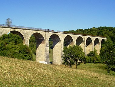
Viaduc d'Ariéthal, 2010
| ||||||||||||||||||||||||||||||||||||||||||||||||||||||||||||||||||||||||||||||||||||||||||||||||||||||||||||||||||||||||||||||||||
| Route number (SNCF) : | 213,000 | |||||||||||||||||||||||||||||||||||||||||||||||||||||||||||||||||||||||||||||||||||||||||||||||||||||||||||||||||||||||||||||||||
| Course book route (SNCF) : | 60, 61 (1935) | |||||||||||||||||||||||||||||||||||||||||||||||||||||||||||||||||||||||||||||||||||||||||||||||||||||||||||||||||||||||||||||||||
| Route length: | 74.5 km | |||||||||||||||||||||||||||||||||||||||||||||||||||||||||||||||||||||||||||||||||||||||||||||||||||||||||||||||||||||||||||||||||
| Gauge : | 1435 mm ( standard gauge ) | |||||||||||||||||||||||||||||||||||||||||||||||||||||||||||||||||||||||||||||||||||||||||||||||||||||||||||||||||||||||||||||||||
| Maximum slope : | 7 ‰ | |||||||||||||||||||||||||||||||||||||||||||||||||||||||||||||||||||||||||||||||||||||||||||||||||||||||||||||||||||||||||||||||||
| Dual track : | Yes | |||||||||||||||||||||||||||||||||||||||||||||||||||||||||||||||||||||||||||||||||||||||||||||||||||||||||||||||||||||||||||||||||
|
||||||||||||||||||||||||||||||||||||||||||||||||||||||||||||||||||||||||||||||||||||||||||||||||||||||||||||||||||||||||||||||||||
The Marcq-Saint-Juvin-Baroncourt railway was a double-track , strategic railway line in northern France . It connected Reims and Laon over a large area with the preliminary line Challerange – Apremont-sur-Aire in the west via the connecting line Baroncourt – Audun-le-Roman with the Metz and Thionville region in the east. All connections - including those to the Lérouville – Pont-Maugis railway line - were designed to be free of crossings in order to achieve the most efficient transport possible, some of which required kilometer-long connecting curves. The route was dimensioned so that it could handle 72 military trains in 24 hours at a top speed of 30 to 35 km / h. There were several military stations along the route with infrastructure for loading military equipment and troops. Because of the sparsely populated area, there were very few civilian stops. The largest single structure is the Viaduc d'Exermont , which is also known under the name Viaduc d'Ariéthal , which climbers can try their hand at today and where bungee jumps are made.
history

A license application for the construction and operation of this line was made in 1922/23. The opening took place on April 12, 1935 and was not a commercial trend from the start. Thus, only military transports took place, especially in the years 1938 to 1940.
Only a few evidence of this era are still visible today. In addition to the aforementioned Viaduc d'Exermont ⊙ , in the Moraigne district near Billy there are, for example, three of the originally four concreted semicircular passages that were located close to each other and which ran under a railway embankment ⊙ and the concrete bridge over the overpass of the CFW-Société- Économique railway at Damvillers - Peuvillers ⊙ has been preserved.
In Damvillers-Peuvillers, between 1914 and 1938, there was a connection to the 150 km long meter gauge network of the Société économiques (SE), formerly Réseau de la Woëvre (CFW). This company, founded in 1907, did not survive the First World War with its prolonged trench warfare, as the route was exactly in the contested area. It supplied the necessary materials for the reconstruction of the destroyed villages and the infrastructure, but the hyperinflation of 1923 put an end to it: On June 1, 1923 the company closed. The property went to the Compagnie Meusienne and the Société Géneral des Chemins de fer Economiques (SGCFE), but this company, too, was unable to defy the increasingly developed road network. Operations ceased here in 1936. The liquidation of the assets of the SGCFE network had not yet been completed when the Second World War broke out in 1939.
The viaduct was blown up twice. The first time a hole was torn when an arch was opened by the French army in the summer of 1940. The Wehrmacht rebuilt the bridge in 1941, but removed one track from the double-track line in 1943. When she withdrew in 1944, she also blew up the viaduct so as not to leave an intact infrastructure. It was also rebuilt afterwards, but on May 24, 1951, it was closed and dismantled.
literature
- Pascal Dumont, Olivier Geerinck: Sur Les Rails d'Ardennes et de Gaume. Volume 14, Editions du Cabri 2004, ISBN 978-28449-4269-2
Individual evidence
- ↑ Chemins de fer de l'est. Materiel et traction . In: Carnet de Marches-Types pour trains spéciaux , 1935
- ↑ Inventaire des lignes oubliées. Historic railway lines (French)
- ↑ Les gares de la ligne stratégiqued'Autrecourt à Marcq . Horizon d'Argonne, No. 95, June 2018, pages 81-90
- ^ List des chemins de fer secondaires , FACS - Patrimoine Ferroviaire, Paris
- ^ Marcq St Juvin - Baroncourt on rue-du-petit-train
- ↑ Inventaires Ponts et viaducs detruits et / ou disparus. on inventaires-ferroviaires
- ↑ Loi déclarant d'utilité publique l'établissement, dans le département de la Meuse, d'un réseau de Chemins de fer d'intérêt local, à voie d'un mètre, dit Réseau de la Woëvre, composé des deux lignes de Verdun à Montmédy et de Commercy à Verdun. In: Bulletin des lois de la République française. Paris, July 1907
- ↑ Günter Dinhobl: Across the Borders: Financing the World's Railways in the Nineteenth and Twentieth Centuries. Routledge 2017, ISBN 978-13519-6100-4 , pp. 82– / 85
- ↑ L'histoire du Meusien: Le déclin. On: Chemin de Fer Historique de la Voie Sacrée.

