
Billy-sous-Mangiennes
| Billy-sous-Mangiennes | ||
|---|---|---|

|
|
|
| region | Grand Est | |
| Department | Meuse | |
| Arrondissement | Verdun | |
| Canton | Bouligny | |
| Community association | Damvillers Spincourt | |
| Coordinates | 49 ° 20 ' N , 5 ° 35' E | |
| height | 202-250 m | |
| surface | 24.66 km 2 | |
| Residents | 373 (January 1, 2017) | |
| Population density | 15 inhabitants / km 2 | |
| Post Code | 55230 | |
| INSEE code | 55053 | |
_mairie.JPG) Billy-sous-Mangiennes town hall |
||

Billy-sous-Mangiennes is a French commune with 373 inhabitants (as of January 1, 2017) in the Meuse department in the Grand Est region (until 2015 Lorraine ). It belongs to the Arrondissement of Verdun and the Canton of Bouligny (until 2015: Canton of Spincourt ). The inhabitants are called billesois .
geography
Billy-sous-Mangiennes is located about 52 kilometers northwest of Metz and about 35 kilometers northeast of Verdun on the Loison . Billy-sous-Mangiennes is surrounded by the neighboring communities of Mangiennes in the north and west, Pillon in the north, Duzey in the northeast, Muzeray in the east, Loison in the south and southeast, Gremilly in the south and southwest and Azannes-et-Soumazannes in the west and southwest.
Population development
| year | 1962 | 1968 | 1975 | 1982 | 1990 | 1999 | 2006 | 2013 |
| Residents | 452 | 394 | 383 | 366 | 355 | 297 | 367 | 375 |
| Source: Cassini and INSEE | ||||||||
Attractions
- 12th century Romanesque church of Saint-Loup, rebuilt in 1771, bell tower destroyed in 1914, rebuilt in 1927
- Notre-Dame chapel from 1746
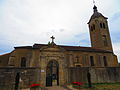
Saint-Loup church

Notre-Dame chapel


literature
- Le Patrimoine des Communes de la Meuse. Flohic Editions, Volume 2, Paris 1999, ISBN 2-84234-074-4 , pp. 911-912.