
Brocourt-en-Argonne
| Brocourt-en-Argonne | ||
|---|---|---|
|
||
| region | Grand Est | |
| Department | Meuse | |
| Arrondissement | Verdun | |
| Canton | Clermont-en-Argonne | |
| Community association | Argonne-Meuse | |
| Coordinates | 49 ° 7 ' N , 5 ° 10' E | |
| height | 208-297 m | |
| surface | 6.71 km 2 | |
| Residents | 47 (January 1, 2017) | |
| Population density | 7 inhabitants / km 2 | |
| Post Code | 55120 | |
| INSEE code | 55082 | |
_city_limit_sign_(02).JPG) Entry into Brocourt-en-Argonne |
||

Brocourt-en-Argonne is a French commune with 47 inhabitants (as of January 1, 2017) in the Meuse department in the Grand Est region (before 2016: Lorraine ). The municipality belongs to the Arrondissement Verdun , the canton Clermont-en-Argonne and the municipal association Argonne-Meuse .
geography
The Cousances runs in a north-westerly direction through the western municipality. Brocourt-en-Argonne is surrounded by the neighboring municipalities of Clermont-en-Argonne in the south and south-west, Brabant-en-Argonne in the north-west and north, Dombasle-en-Argonne and Jouy-en-Argonne in the north-east and by the canton Dieue- sur-Meuse communes of Nixéville-Blercourt in the east and Les Souhesmes-Rampont in the southeast.
history
The village was first mentioned in 1051 under the name Beroldi Curtis . It was part of the Diocese of Verdun and was under the judiciary of the Princes of Condé .
The community was founded in 1793 under the name Brocourt and has had its current name since 1924.
Population development
| year | 1962 | 1968 | 1975 | 1982 | 1990 | 2006 | 2011 | 2016 |
| Residents | 89 | 79 | 65 | 58 | 60 | 51 | 47 | 47 |
| Source: Cassini and INSEE | ||||||||
Attractions
- Saint-Michel church built in the late 17th century. Its bell tower was built in 1876. It was destroyed in World War I and restored after the war.
- Nécropole nationale Brocourt-en-Argonne military cemetery
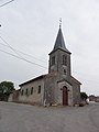
Saint-Michel church

Entrance to the Nécropole nationale Brocourt-en-Argonne à Récicourt

Burial ground of the Nécropole nationale Brocourt-en-Argonne à Récicourt

Burial ground of the Nécropole nationale Brocourt-en-Argonne à Récicourt
_%C3%A9glise_(01).JPG)
_N%C3%A9cropole_nationale_Brocourt-en-Argonne_%C3%A0_Recicourt_(01).JPG)
_N%C3%A9cropole_nationale_Brocourt-en-Argonne_%C3%A0_Recicourt_(02).JPG)
_N%C3%A9cropole_nationale_Brocourt-en-Argonne_%C3%A0_Recicourt_(04).JPG)
literature
- Le Patrimoine des Communes de la Meuse. Flohic Edition, Paris 1999, ISBN 2-84234-074-4 .