
Ronvaux
| Ronvaux | ||
|---|---|---|

|
|
|
| region | Grand Est | |
| Department | Meuse | |
| Arrondissement | Verdun | |
| Canton | Etain | |
| Community association | Territoire de Fresnes-en-Woëvre | |
| Coordinates | 49 ° 8 ' N , 5 ° 33' E | |
| height | 217-362 m | |
| surface | 2.63 km 2 | |
| Residents | 88 (January 1, 2017) | |
| Population density | 33 inhabitants / km 2 | |
| Post Code | 55160 | |
| INSEE code | 55439 | |
_mairie-%C3%A9cole.JPG) Town hall ( Mairie ) and school of Ronvaux |
||

Ronvaux is a French commune with 88 inhabitants (as of January 1, 2017) in the Meuse department in the Grand Est region (before 2016: Lorraine ). The municipality belongs to the arrondissement of Verdun , the canton Étain (until 2015: canton Fresnes-en-Woëvre ) and the municipality association Territoire de Fresnes-en-Woëvre
geography
The municipality is located in the Lorraine Regional Nature Park, founded in 1974 . Ronvaux is surrounded by the neighboring municipalities of Watronville in the north, Manheulles in the east and Haudiomont in the south and west.
Population development
| year | 1962 | 1968 | 1975 | 1982 | 1990 | 1999 | 2006 | 2011 | 2017 |
| Residents | 100 | 61 | 60 | 69 | 75 | 83 | 86 | 95 | 88 |
| Source: Cassini and INSEE | |||||||||
Attractions
- Church of the Assumption of the Blessed Virgin (Église de l'Assomption-de-la-Sainte-Vierge), built in 1781, destroyed in World War I and rebuilt in 1928
- Memorial to the dead of the First World War

Church of the Assumption of the Blessed Virgin
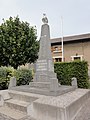
Memorial to the war dead at Ronvaux

_monument_aux_morts_(01).JPG)
literature
- Le Patrimoine des Communes de la Meuse. Flohic Editions, Volume 1, Paris 1999, ISBN 2-84234-074-4 , pp. 458-460.
Web links
Commons : Ronvaux - collection of images, videos and audio files