
Vilosnes-Haraumont
| Vilosnes-Haraumont | ||
|---|---|---|
|
||
| region | Grand Est | |
| Department | Meuse | |
| Arrondissement | Verdun | |
| Canton | Clermont-en-Argonne | |
| Community association | Pays de Stenay et du Val Dunois | |
| Coordinates | 49 ° 20 ' N , 5 ° 14' E | |
| height | 174-387 m | |
| surface | 15.41 km 2 | |
| Residents | 221 (January 1, 2017) | |
| Population density | 14 inhabitants / km 2 | |
| Post Code | 55110 | |
| INSEE code | 55571 | |
 Town hall (Mairie) of Vilosnes-Haraumont |
||

Vilosnes-Haraumont is a French commune with 221 inhabitants (as of January 1, 2017) in the Meuse department in the Grand Est region (before 2016: Lorraine ). The municipality belongs to the arrondissement of Verdun and the canton of Clermont-en-Argonne (until 2015: canton of Dun-sur-Meuse ).
geography
Vilosnes-Haraumont is located about 30 kilometers north-north-west of Verdun on the Meuse (French: Meuse ). Vilosnes-Haraumont is surrounded by the neighboring communities of Liny-devant-Dun in the north and north-west, Fontaines-Saint-Clair in the north, Bréhéville in the north-east, Écurey-en-Verdunois in the east and north-east, Réville-aux-Bois in the east, Sivry- sur-Meuse in the south and southeast, Dannevoux in the south and Brieulles-sur-Meuse in the west.
history
In 1973 Vilosnes and Haraumont were merged.
Population development
| year | 1962 | 1968 | 1975 | 1982 | 1990 | 1999 | 2006 | 2011 | 2016 |
| Residents | 260 | 271 | 257 | 235 | 231 | 212 | 202 | 208 | 218 |
| Source: Cassini and INSEE | |||||||||
Attractions
- Saint-Barthélemy Church in Vilosnes, built in 1778
- Saint-Firmin Church in Haraumont, built in 1771
- Chapel of Les Naufragés rebuilt in the 19th century

Saint Barthélemy Church

Saint-Firmin church
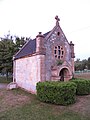
Chapel of Les Naufragés


literature
- Le Patrimoine des Communes de la Meuse. Flohic Editions, Volume 1, Paris 1999, ISBN 2-84234-074-4 , pp. 375-377.