
Pareid
| Pareid | ||
|---|---|---|
|
||
| region | Grand Est | |
| Department | Meuse | |
| Arrondissement | Verdun | |
| Canton | Etain | |
| Community association | Territoire de Fresnes-en-Woëvre | |
| Coordinates | 49 ° 7 ' N , 5 ° 43' E | |
| height | 198-225 m | |
| surface | 7.02 km 2 | |
| Residents | 119 (January 1, 2017) | |
| Population density | 17 inhabitants / km 2 | |
| Post Code | 55160 | |
| INSEE code | 55399 | |

Pareid is a French commune with 119 inhabitants (as of January 1, 2017) in the Meuse department in the Grand Est region (until 2015: Lorraine ). The municipality belongs to the arrondissement of Verdun and the Territoire de Fresnes-en-Woëvre, founded in 1996 . The residents call themselves Pareidois .
geography
The municipality of Pareid is located about 30 kilometers southeast of Verdun in the Woëvre region . The rivers in the 7.02 km² municipal area of Pareid drain via Longeau , Yron and Orne to the Moselle . The predominantly flat municipal area, characterized by fields and meadows, has a 250-hectare forest in the north ( Grand Bois, Petit Bois ). Pareid is surrounded by the neighboring communities Parfondrupt in the north, Villers-sous-Pareid in the east, Harville and Maizeray in the south, Pintheville in the southwest and Hennemont in the northwest.
Place name
The place first appeared in 701 as Pararicum . The name developed via Parrida (952), Parridum (952), Pararium (1049), Parois (1223), Pareis (1253), Parers and Parrey 1315 (), Parex and Parez-en-Woyvre (1549), Parey- en-Voipvre (1564), Parecium (1580), Pareys (1642) and Parreys (1656) for the spelling Pareid, which has been in use since 1793 .
Population development
| year | 1962 | 1968 | 1975 | 1982 | 1990 | 1999 | 2006 | 2016 |
| Residents | 142 | 132 | 112 | 102 | 93 | 79 | 108 | 120 |
| Sources: Cassini and INSEE | ||||||||
Attractions
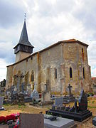
- listed fortified church Saint-Remi with tower and tower inscription on black marble from the 12th century nave of the 15th century, during World War badly damaged and rebuilt
- Saint-Remi church


.jpg)
Economy and Infrastructure
Seven farms are located in Pareid (dairy farming, cattle and horse breeding).
The A4 autoroute runs from Paris to Strasbourg on the northern edge of the municipality of Pareid . The railway lines Saint-Hilaire-au-Temple-Hagondange , Longuyon-Pagny-sur-Moselle and Conflans-Jarny-Metz cross at the train station in the small town of Jarny , 15 kilometers away .
literature
- Le Patrimoine des Communes de la Meuse. Flohic Editions, Volume 1, Paris 1999, ISBN 2-84234-074-4 , p. 456.
supporting documents
- ↑ Pareid in the Dictionnaire topographique de la France (French)
- ↑ Pareid on cassini.ehess.fr
- ↑ Pareid on insee.fr
- ^ Entry in the Base Mérimée of the Ministry of Culture. Retrieved July 5, 2019 (French).
- ^ Farmers on annuaire-mairie.fr