
Bonzée
| Bonzée | ||
|---|---|---|
|
||
| region | Grand Est | |
| Department | Meuse | |
| Arrondissement | Verdun | |
| Canton | Etain | |
| Community association | Territoire de Fresnes-en-Woëvre | |
| Coordinates | 49 ° 6 ′ N , 5 ° 36 ′ E | |
| height | 228-391 m | |
| surface | 21.14 km 2 | |
| Residents | 350 (January 1, 2017) | |
| Population density | 17 inhabitants / km 2 | |
| Post Code | 55160 | |
| INSEE code | 55060 | |
 Town hall (Mairie) of Bonzée |
||

Bonzée is a French commune with 350 inhabitants (as of January 1, 2017) in the Meuse department in the Grand Est region (until 2015: Champagne-Ardenne ). The municipality belongs to the Arrondissement of Verdun and the Canton of Étain (until 2015: Canton Fresnes-en-Woëvre ).
geography
Bonzée is located about 17 kilometers east-southeast of Verdun and about 42 kilometers west of Metz in the Woëvre region . Bonzée is surrounded by the neighboring communities of Haudiomont in the north and north-west, Manheulles in the north, Fresnes-en-Woëvre in the east, Trésauvaux in the south-east, Les Éparges in the south, Mouilly in the south and south-west and Rupt-en-Woëvre in the west and south-west.
history
Bonzée emerged in 1977 from the previously independent municipalities of Bonzée-en-Woëvre , Mesnil-sous-les-Côtes and Mont-Villers .
Population development
| year | 1962 | 1968 | 1975 | 1982 | 1990 | 1999 | 2008 | 2013 |
| Residents | 159 | 133 | 131 | 306 | 328 | 350 | 362 | 354 |
| Source: Cassini and INSEE | ||||||||
Attractions
- Saint-Laurent church in Bonzée, rebuilt in 1927
- Saint-Brice church in Mesnil-sous-les-Côtes, rebuilt in 1924
- Saint-Martin church in Mont-Villers, built in 1769
- French National Cemetery in Mont-Villers

Saint Laurent Church

Saint-Brice church

Saint Martin Church
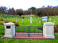
Mont-Villers National Cemetery


literature
- Le Patrimoine des Communes de la Meuse. Flohic Editions, Volume 1, Paris 1999, ISBN 2-84234-074-4 , pp. 425-429.