
Brieulles-sur-Meuse
| Brieulles-sur-Meuse | ||
|---|---|---|

|
|
|
| region | Grand Est | |
| Department | Meuse | |
| Arrondissement | Verdun | |
| Canton | Clermont-en-Argonne | |
| Community association | Pays de Stenay et du Val Dunois | |
| Coordinates | 49 ° 20 ' N , 5 ° 11' E | |
| height | 174-298 m | |
| surface | 24.05 km 2 | |
| Residents | 315 (January 1, 2017) | |
| Population density | 13 inhabitants / km 2 | |
| Post Code | 55110 | |
| INSEE code | 55078 | |
 Town hall (Mairie) of Brieulles-sur-Meuse |
||

Brieulles-sur-Meuse is a French commune with 315 inhabitants (as of January 1, 2017) in the Meuse department in the Grand Est region (before 2016: Lorraine ). The municipality belongs to the arrondissement of Verdun and the canton of Stenay (until 2015: canton of Dun-sur-Meuse ). The inhabitants are called Brieulans .
geography
Brieulles-sur-Meuse is about 30 kilometers north-north-west of Verdun on the Meuse (French: Meuse ). Brieulles-sur-Meuse is surrounded by the neighboring communities Cléry-le-Grand in the north and north-west, Cléry-le-Petit in the north, Liny-sur-Dun in the east and north-east, Vilosnes-Haraumont in the east, Dannevoux in the south and south-east, Septsarges in the south, Nantillois in the southwest and Cunel in the west.
Population development
| year | 1962 | 1968 | 1975 | 1982 | 1990 | 1999 | 2006 | 2011 | 2016 |
| Residents | 532 | 482 | 431 | 391 | 356 | 322 | 332 | 335 | 325 |
| Source: Cassini and INSEE | |||||||||
Attractions
- Sainte-Vierge-de-l'Assomption Church, built in 1774
- Premonstratensian priory with chapel from 1751, monument historique since 1994
- French national cemetery
- German military cemeteries in Brieulles-sur-Meuse and Cheppy

Sainte-Vierge-de-l'Assomption church

Premonstratensian Priory
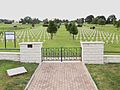
French national cemetery

German military cemetery


literature
- Le Patrimoine des Communes de la Meuse. Flohic Editions, Volume 1, Paris 1999, ISBN 2-84234-074-4 , pp. 344-346.