
Saint-Laurent-sur-Othain
| Saint-Laurent-sur-Othain | ||
|---|---|---|

|
|
|
| region | Grand Est | |
| Department | Meuse | |
| Arrondissement | Verdun | |
| Canton | Bouligny | |
| Community association | Damvillers Spincourt | |
| Coordinates | 49 ° 24 ' N , 5 ° 32' E | |
| height | 196-286 m | |
| surface | 16.79 km 2 | |
| Residents | 506 (January 1, 2017) | |
| Population density | 30 inhabitants / km 2 | |
| Post Code | 55150 | |
| INSEE code | 55461 | |
_mairie.JPG) Town hall (Mairie) of Saint-Laurent-sur-Othain |
||

Saint-Laurent-sur-Othain is a French commune with 506 inhabitants (as of January 1, 2017) in the Meuse department in the Grand Est region (until 2015 Lorraine ). It belongs to the Arrondissement of Verdun and the Canton of Bouligny (until 2015: Canton of Spincourt ).
geography
Saint-Laurent-sur-Othain is located about 54 kilometers northwest of Metz and about 37 kilometers northeast of Verdun am Othain . Saint-Laurent-sur-Othain is surrounded by the neighboring communities of Grand-Failly in the north and west, Sorbey in the east, Pillon in the south-east, Mangiennes and Villers-lès-Mangiennes in the south and Merles-sur-Loison in the south-west.
Population development
| year | 1962 | 1968 | 1975 | 1982 | 1990 | 1999 | 2006 | 2013 |
| Residents | 484 | 452 | 442 | 432 | 377 | 370 | 467 | 497 |
| Source: Cassini and INSEE | ||||||||
Attractions
- Saint-Laurent church from the 18th century
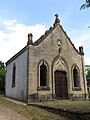
- Notre-Dame-de-Bon-Secours chapels (built in 1832) and Notre-Dame-du-Luxembourg (built in 1872)
- Wash house
- Mill at Othain

Saint Laurent Church

Notre-Dame-de-Bon-Secours chapel
Notre-Dame-du-Luxembourg chapel

Mill at Othain


_moulin_%C3%A0_eau.JPG)
literature
- Le Patrimoine des Communes de la Meuse. Flohic Editions, Volume 2, Paris 1999, ISBN 2-84234-074-4 , pp. 924-925.