
Dugny-sur-Meuse
| Dugny-sur-Meuse | ||
|---|---|---|
|
||
| region | Grand Est | |
| Department | Meuse | |
| Arrondissement | Verdun | |
| Canton | Verdun-2 | |
| Community association | Val de Meuse-Voie Sacrée | |
| Coordinates | 49 ° 6 ' N , 5 ° 23' E | |
| height | 185-328 m | |
| surface | 19 km 2 | |
| Residents | 1,307 (January 1, 2017) | |
| Population density | 69 inhabitants / km 2 | |
| Post Code | 55100 | |
| INSEE code | 55166 | |
| Website | http://www.dugnysurmeuse.fr/ | |

Dugny-sur-Meuse is a French commune with 1,307 inhabitants (as of January 1, 2017) in the Meuse department in the Grand Est region (until 2015: Lorraine ). The municipality belongs to the Arrondissement of Verdun , the canton Verdun-2 (until 2015: Canton Verdun-Center ) and the community association Communauté de communes du Val de Meuse et de la Vallée de la Dieue .
geography
Dugny-sur-Meuse is located about five kilometers south of Verdun on the Meuse (French: Meuse ), which forms the eastern municipal boundary. Dugny-sur-Meuse is surrounded by the neighboring municipalities of Belleray in the north, Haudainville in the north-east, Dieue-sur-Meuse in the east and south-east, Ancemont in the south and south-east, Senoncourt-les-Maujouy in the south and south-west and Landrecourt-Lempire in the west.
The A4 autoroute runs through the municipality .
Population development
| year | 1962 | 1968 | 1975 | 1982 | 1990 | 1999 | 2006 | 2013 |
|---|---|---|---|---|---|---|---|---|
| Residents | 1,221 | 1,284 | 1,181 | 1,224 | 1,247 | 1,279 | 1,324 | 1,287 |
| Source: Cassini and INSEE | ||||||||
Attractions
- Old and New Nativité-de-la-Vierge Church
- Saint-Pierre-Saint-Paul Chapel in Billemont
- National Cemetery
- Lavoir (wash house)
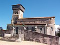
Old church Nativité-de-la-Vierge

New church Nativité-de-la-Vierge

Saint-Pierre-Saint-Paul Chapel


literature
- Le Patrimoine des Communes de la Meuse. Flohic Editions, Volume 2, Paris 1999, ISBN 2-84234-074-4 , pp. 1098-1101.