
Watronville
| Watronville | ||
|---|---|---|
|
||
| region | Grand Est | |
| Department | Meuse | |
| Arrondissement | Verdun | |
| Canton | Etain | |
| Community association | Territoire de Fresnes-en-Woëvre | |
| Coordinates | 49 ° 8 ' N , 5 ° 33' E | |
| height | 215-363 m | |
| surface | 6.39 km 2 | |
| Residents | 105 (January 1, 2017) | |
| Population density | 16 inhabitants / km 2 | |
| Post Code | 55160 | |
| INSEE code | 55579 | |
_mairie-%C3%A9cole.JPG) Town hall and school building |
||

Watronville is a French commune with 105 inhabitants (as of January 1, 2017) in the Meuse department in the Grand Est region (until 2015 Lorraine ). It belongs to the Arrondissement of Verdun and the Territoire de Fresnes-en-Woëvre, founded in 1996 . The inhabitants are called Watronvillois .
geography
_city_limit_sign.JPG)
The municipality of Watronville is located at the foot of the Côtes de Meuse range of hills in the Woëvre region , about twelve kilometers east of Verdun . Several streams that have their source in the Watronville parish drain northeast to the Orne . The 6.39 km² community area can be divided into two parts: the northeast is flat and characterized by a mixture of forest, pasture and arable land. This flat land, which is about 230 meters above sea level, faces an almost completely wooded ( Bois de Marchéville, Bois de l'Hôte ) high plateau in the southwest, reaching up to 360 meters . The dividing line between the two landscapes forms a steep step, the slopes of which face east to northeast. Wine is cultivated here that is part of the northernmost tip of the Côtes de Meuse wine-growing region . In the middle of the vines is the village of Watronville. Immediately west of the municipality is the restricted military area of the Champ de Tir du Rozelier training area . Watronville is surrounded by the neighboring communities of Grimaucourt-en-Woëvre in the northeast, Manheulles in the east, Ronvaux in the southeast, Haudiomont in the south and Châtillon-sous-les-Côtes in the west.
Place name
The name of the community developed using the following spellings:
- Mid-12th century: Ventonis villa
- 1177: Wentrunville
- 1240: Wantronville
- 1593: Vuatronville
- 1622: Watronville
- 1756: Vatronville
- since 1793: Watronville
Population development
| year | 1962 | 1968 | 1975 | 1982 | 1990 | 1999 | 2007 | 2017 | |
| Residents | 133 | 134 | 104 | 101 | 112 | 103 | 107 | 105 | |
| Sources: Cassini and INSEE | |||||||||
In 1836 the highest number of inhabitants was determined with 506 inhabitants.
Attractions
- Church of the Assumption ( Église de l'Assomption de la Vierge ) from the 18th century, reconstructed in 1929
- War memorial
- Grave of 17-year-old Jean Scharinger, who died in 1944
- former castle from the 15th century
- Hallway crosses, including a richly decorated iron one
- Virgin Mary statue

Church of the Assumption

former castle
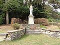
Virgin Mary statue

iron floor cross

War memorial

Tomb for Jean Scharinger


_statue-oratoire_de_la_Vierge.JPG)
_croix_de_chemin_(01),_la_croix.JPG)
_monument_aux_morts_(01).JPG)
_memorial_Jean_Scharinger_1944.JPG)
Economy and Infrastructure
Six farms are located in Watronville (grain cultivation, orchards). The D24 trunk road from Eix to Haudiomont runs through the community . The A4 Autoroute runs from Paris to Strasbourg just south of Watronville .
literature
- Le Patrimoine des Communes de la Meuse. Flohic Editions, Volume 1, Paris 1999, ISBN 2-84234-074-4 , pp. 470-471.
supporting documents
- ↑ Dictionnaire topographique de la France (French)
- ↑ Watronville on cassini.ehess.fr
- ↑ Watronville on insee.fr
- ↑ Farmers in Watronville on annuaire-mairie.fr (French)