
Bouligny
| Bouligny | ||
|---|---|---|

|
|
|
| region | Grand Est | |
| Department | Meuse | |
| Arrondissement | Verdun | |
| Canton | Bouligny (main town) | |
| Community association | Pays de l'Audunois et du Bassin de Landres | |
| Coordinates | 49 ° 18 ' N , 5 ° 45' E | |
| height | 238-316 m | |
| surface | 10.99 km 2 | |
| Residents | 2,558 (January 1, 2017) | |
| Population density | 233 inhabitants / km 2 | |
| Post Code | 55240 | |
| INSEE code | 55063 | |
 Bouligny town hall |
||

Bouligny is a French commune with 2,558 inhabitants (as of January 1, 2017) in the Meuse department in the Grand Est region (until 2016 Lorraine ). It belongs to the Arrondissement of Verdun and the Canton of Bouligny (until 2015: Canton of Spincourt ). The inhabitants are called Boulinéens .
geography
Bouligny is located about 37 kilometers northwest of Metz and about 30 kilometers northeast of Verdun on the border with the Meurthe-et-Moselle department . Bouligny is surrounded by the neighboring communities of Avillers and Domprix in the north, Piennes in the northeast, Joudreville in the east, Affléville in the south and Dommary-Baroncourt in the west.
history
The place was first mentioned as Bulinium in the 13th century .
Population development
| year | 1962 | 1968 | 1975 | 1982 | 1990 | 1999 | 2006 | 2012 |
| Residents | 5,374 | 4,647 | 4.022 | 3,575 | 2,951 | 2,813 | 2,750 | 2,697 |
Attractions
- Sainte-Pétronille church from the 17th century
- Chapel of Sainte-Jeanne-d'Arc from the 20th century
- Sainte-Barbe Chapel from the 20th century
- German military cemetery from the First World War

Sainte-Pétronille church

Chapel of Sainte-Jean-d'Arc in the village of Mourières
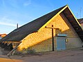
Sainte-Barbe chapel in the Saint-Pierre district

German military cemetery with 1,439 dead


literature
- Le Patrimoine des Communes de la Meuse. Flohic Editions, Volume 2, Paris 1999, ISBN 2-84234-074-4 , pp. 913-914.