
Champneuville
| Champneuville | ||
|---|---|---|

|
|
|
| region | Grand Est | |
| Department | Meuse | |
| Arrondissement | Verdun | |
| Canton | Belleville-sur-Meuse | |
| Community association | Grand Verdun | |
| Coordinates | 49 ° 14 ' N , 5 ° 20' E | |
| height | 181-337 m | |
| surface | 11.99 km 2 | |
| Residents | 120 (January 1, 2017) | |
| Population density | 10 inhabitants / km 2 | |
| Post Code | 55100 | |
| INSEE code | 55099 | |
| Website | http://www.champneuville.fr/ | |

Champneuville is a French commune with 120 inhabitants (as of January 1, 2017) in the Meuse department in the Grand Est region (before 2016 Lorraine ). The municipality belongs to the arrondissement of Verdun and the canton of Belleville-sur-Meuse (until 2015 Charny-sur-Meuse ).
geography
Champneuville is located about seven kilometers north-northwest of Verdun on the Canal de la Meuse and the Maas (French: Meuse ). Champneuville is surrounded by the neighboring communities of Brabant-sur-Meuse and Samogneux in the north, Beaumont-en-Verdunois in the northeast, Louvemont-Côte-du-Poivre in the east and northeast, Charny-sur-Meuse in the south, Marre in the south and southwest, Chattancourt in the southwest and Cumières-le-Mort-Homme in the west.
Population development
| year | 1962 | 1968 | 1975 | 1982 | 1990 | 1999 | 2006 | 2013 |
| Residents | 106 | 97 | 94 | 90 | 92 | 105 | 114 | 123 |
| Source: Cassini and INSEE | ||||||||
Attractions
- Notre-Dame-de-l'Assomption church, rebuilt in 1929
- La Vierge-de-l'Orme chapel, rebuilt in 1925
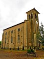
Notre-Dame-de-l'Assomption church

La Vierge-de-l'Orme chapel


literature
- Le Patrimoine des Communes de la Meuse. Flohic Editions, Volume 1, Paris 1999, ISBN 2-84234-074-4 , pp. 162-165.