
Amel-sur-l'Étang
| Amel-sur-l'Étang | ||
|---|---|---|
|
||
| region | Grand Est | |
| Department | Meuse | |
| Arrondissement | Verdun | |
| Canton | Bouligny | |
| Community association | Damvillers Spincourt | |
| Coordinates | 49 ° 16 ' N , 5 ° 39' E | |
| height | 205-256 m | |
| surface | 14.74 km 2 | |
| Residents | 151 (January 1, 2017) | |
| Population density | 10 inhabitants / km 2 | |
| Post Code | 55230 | |
| INSEE code | 55008 | |
_mairie.JPG) Town hall ( Mairie ) of Amel-sur-l'Étang |
||

Amel-sur-l'Étang is a French commune with 151 inhabitants (as of January 1, 2017) in the Meuse department in the Grand Est region (before 2016: Lorraine ). The municipality belongs to the Arrondissement Verdun , the canton Bouligny (until 2015: Canton Spincourt ) and the municipal association Damvillers Spincourt . Amel-sur-l'Étang is surrounded by the neighboring municipalities Foameix-Ornel in the southwest, Senon in the northwest and north, Éton in the east, Rouvres-en-Woëvre in the southeast and Étain in the south.
Population development
| year | 1962 | 1968 | 1975 | 1982 | 1990 | 1999 | 2006 | 2012 | 2016 |
| Residents | 299 | 227 | 192 | 168 | 132 | 150 | 164 | 176 | 159 |
| Source: Cassini and INSEE | |||||||||
Attractions
- Saint-Martin Church, built in 1780
- German military cemetery with 2,284 fallen from the First World War
- Réserve naturelle régionale de l'étang d'Amel , 146.59 ha regional nature reserve on the territory of the municipalities of Amel-sur-l'Étang and Senon.
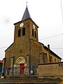
Saint Martin Church

German military cemetery

RNR de l'étang d'Amel, looking south-west


literature
- Le Patrimoine des Communes de la Meuse. Flohic Editions, Volume 2, Paris 1999, ISBN 2-84234-074-4 , p. 909.
Web links
Commons : Amel-sur-l'Étang - Collection of images, videos and audio files