
Rouvrois-sur-Othain
| Rouvrois-sur-Othain | ||
|---|---|---|

|
|
|
| region | Grand Est | |
| Department | Meuse | |
| Arrondissement | Verdun | |
| Canton | Bouligny | |
| Community association | Damvillers Spincourt | |
| Coordinates | 49 ° 23 ' N , 5 ° 38' E | |
| height | 218-301 m | |
| surface | 12.56 km 2 | |
| Residents | 194 (January 1, 2017) | |
| Population density | 15 inhabitants / km 2 | |
| Post Code | 55230 | |
| INSEE code | 55445 | |
_mairie.JPG) Town hall ( Mairie ) and school of Rouvrois-sur-Othain |
||

Rouvrois-sur-Othain is a French commune with 194 inhabitants (as of January 1, 2017) in the Meuse department in the Grand Est region (before 2016: Lorraine ). The municipality belongs to the arrondissement Verdun , the canton Bouligny (until 2015: canton Spincourt ) and the municipal association Damvillers Spincourt . Rouvrois-sur-Othain is surrounded by the neighboring communities of Sorbey in the northwest, Arrancy-sur-Crusne in the northeast, Saint-Pierrevillers in the east, Nouillonpont in the southeast, Duzey in the south and Pillon in the west.
Population development
| year | 1962 | 1968 | 1975 | 1982 | 1990 | 1999 | 2004 | 2009 | 2016 |
| Residents | 223 | 184 | 184 | 218 | 201 | 190 | 182 | 201 | 197 |
| Source: Cassini and INSEE | |||||||||
Attractions
- Saint-Félix church, built in 1738
- Memorial to the dead of the First World War
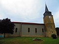
Saint-Félix church

Memorial to the war dead

_monument_aux_morts_(01).JPG)
literature
- Le Patrimoine des Communes de la Meuse. Flohic Editions, Volume 2, Paris 1999, ISBN 2-84234-074-4 , p. 924.
Web links
Commons : Rouvrois-sur-Othain - Collection of images, videos and audio files