
Fromezey
| Fromezey | ||
|---|---|---|

|
|
|
| region | Grand Est | |
| Department | Meuse | |
| Arrondissement | Verdun | |
| Canton | Etain | |
| Community association | Pays d'Étain | |
| Coordinates | 49 ° 13 ' N , 5 ° 35' E | |
| height | 203-230 m | |
| surface | 5.96 km 2 | |
| Residents | 53 (January 1, 2017) | |
| Population density | 9 inhabitants / km 2 | |
| Post Code | 55400 | |
| INSEE code | 55201 | |
_mairie-%C3%A9cole.JPG) City Hall ( Mairie ) and Fromezey School |
||

Fromezey is a French commune with 53 inhabitants (as of January 1, 2017) in the Meuse department in the Grand Est region (until 2015: Lorraine ). The municipality belongs to the Arrondissement Verdun , the canton Étain and the municipality association Pays d'Étain .
geography
The municipality is located in the Woëvre plain on the Verdun - Étain axis. Fromezey is surrounded by the neighboring municipalities of Étain , the canton capital in the east, Herméville-en-Woëvre in the south, the municipalities of Abaucourt-Hautecourt in the southwest and Dieppe-sous-Douaumont in the west, as well as those in the canton of Bouligny, belonging to the canton Belleville-sur-Meuse located communes of Morgemoulin in the north and Foameix-Ornel in the northeast.
history
During the First World War , the village was completely evacuated and destroyed on February 22, 1916.
Population development
| year | 1962 | 1968 | 1975 | 1982 | 1990 | 1999 | 2004 | 2009 | 2016 |
| Residents | 90 | 75 | 61 | 66 | 55 | 68 | 64 | 55 | 51 |
| Source: Cassini and INSEE | |||||||||
Attractions
- Saint-Martin church, built in the 18th century, destroyed in World War I and rebuilt from 1928 to 1930
- Memorial to the dead of the First World War

Saint Martin Church
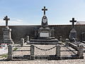
Memorial to the war dead

_Monument_aux_morts_au_cimeti%C3%A8re.JPG)
literature
- Le Patrimoine des Communes de la Meuse. Flohic Editions, Volume 1, Paris 1999, ISBN 2-84234-074-4 , pp. 401-402.