
Aubréville
| Aubréville | ||
|---|---|---|

|
|
|
| region | Grand Est | |
| Department | Meuse | |
| Arrondissement | Verdun | |
| Canton | Clermont-en-Argonne | |
| Community association | Argonne-Meuse | |
| Coordinates | 49 ° 9 ' N , 5 ° 5' E | |
| height | 174-300 m | |
| surface | 20.97 km 2 | |
| Residents | 374 (January 1, 2017) | |
| Population density | 18 inhabitants / km 2 | |
| Post Code | 55120 | |
| INSEE code | 55014 | |
_mairie.JPG) Mairie Aubréville |
||

Aubréville is a commune in the Meuse department in the Grand Est region (until 2015 Lorraine ). It belongs to the Arrondissement of Verdun , the canton of Clermont-en-Argonne and the municipal association Center Argonne .
geography
The municipality of Aubréville, with 374 inhabitants (January 1, 2017), is located in the southeast of the Argonne , about 20 kilometers west of Verdun on the Aire , a tributary of the Aisne . In Aubréville, the approximately 28-kilometer-long Cousances flows into the Aire. In the forest area of Forêt de Hesse in the north of Aubréville is the highest point of the municipality at 300 m. The districts of Courcelles and Lochères belong to Aubréville . Neighboring municipalities of Aubréville are Vauquois and Avocourt in the north, Montzéville in the northeast, Récicourt in the east, Clermont-en-Argonne in the southeast and south and Neuvilly-en-Argonne in the west.
history
The village was first mentioned as Herberici Villa in 701 . It is believed that the small town had around 3,000 inhabitants at the time. Remains of a Roman villa, coins and ceramics have been found from this early settlement period. Agriculture and ceramics production dominated Aubréville for a long time. A stone called Chalaine - also known as Lorraine marble - was used . Aubréville was almost completely destroyed in the First World War.
Population development
| year | 1962 | 1968 | 1975 | 1982 | 1990 | 1999 | 2008 | 2017 | |
| Residents | 488 | 418 | 355 | 359 | 387 | 383 | 398 | 374 | |
| Sources: Cassini and INSEE | |||||||||
Attractions
- St. Martin Church
- Courcelles Castle ( Château de Courcelles ) from the 17th century
- former ceramics factory in the Lochères district
- Castrale Chapel Courcelles

St. Martin Church

Fallen memorial
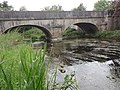
Bridge over the Cousances
_%C3%A9glise_(01).JPG)
_monument_aux_morts_(01).JPG)
_pont_de_la_Cousance_(03).JPG)
Economy and Infrastructure
Eight farms are located in the community (grain cultivation, goat and sheep breeding).
The trunk road from Verdun to Châlons-en-Champagne runs southeast of Aubrécourt ; Six kilometers south of Aubréville there is a connection to the Autoroute A4 ( Paris - Strasbourg ). The Saint-Hilaire-au-Temple-Hagondange railway runs through Aubréville ; However, trains no longer stop in town.
literature
- Le Patrimoine des Communes de la Meuse. Flohic Editions, Volume 1, Paris 1999, ISBN 2-84234-074-4 , pp. 221-224.
supporting documents
- ↑ http://www.centre-argonne.eu/cms/entreprendre/communes/commune-aubreville.html Aubréville on centre-argonne.eu (French)
- ↑ Aubréville on cassini.ehess.fr
- ↑ Aubréville on insee.fr
- ↑ Farms on annuaire-mairie.fr (French)