
Lachalade
| Lachalade | ||
|---|---|---|

|
|
|
| region | Grand Est | |
| Department | Meuse | |
| Arrondissement | Verdun | |
| Canton | Clermont-en-Argonne | |
| Community association | Argonne-Meuse | |
| Coordinates | 49 ° 10 ′ N , 4 ° 58 ′ E | |
| height | 137-273 m | |
| surface | 19.45 km 2 | |
| Residents | 54 (January 1, 2017) | |
| Population density | 3 inhabitants / km 2 | |
| Post Code | 55120 | |
| INSEE code | 55266 | |

Lachalade is a French commune with 54 inhabitants (as of January 1, 2017) in the Meuse department in the Grand Est region (before 2016: Lorraine ). The municipality belongs to the arrondissement Verdun , the canton Clermont-en-Argonne (until 2015: canton Varennes-en-Argonne ) and the municipality association Argonne-Meuse .
geography
Lachalade is about 33 kilometers west-northwest of Verdun . Lachalade is surrounded by the neighboring communities of Boureuilles in the north and east, Neuvilly-en-Argonne in the south and east, Le Claon in the south, Florent-en-Argonne in the south and south-west and Vienne-le-Château in the west and north-west.
Population development
| year | 1962 | 1968 | 1975 | 1982 | 1990 | 1999 | 2006 | 2011 | 2016 |
| Residents | 156 | 131 | 81 | 68 | 57 | 56 | 56 | 66 | 61 |
| Source: Cassini and INSEE | |||||||||
Attractions
- Remains of the Cistercian Abbey of Notre-Dame-en-sa-Purification , founded in 1127/1128, dissolved in 1791, Monument historique since 1862/1931/1986
- French national cemetery
- Cenotaph for the Garibaldi fighters
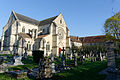
Notre-Dame-en-sa-Purification monastery church

French national cemetery

Cenotaph of the Garibaldi Fighters


Personalities
- Charles-François Dorlodot (1756–1816), Bishop of Laval
literature
- Le Patrimoine des Communes de la Meuse. Flohic Editions, Volume 2, Paris 1999, ISBN 2-84234-074-4 , pp. 985-989.