
Rupt-en-Woëvre
| Rupt-en-Woëvre | ||
|---|---|---|
|
||
| region | Grand Est | |
| Department | Meuse | |
| Arrondissement | Verdun | |
| Canton | Dieue-sur-Meuse | |
| Community association | Val de Meuse-Voie Sacrée | |
| Coordinates | 49 ° 3 ' N , 5 ° 29' E | |
| height | 229-392 m | |
| surface | 17.05 km 2 | |
| Residents | 299 (January 1, 2017) | |
| Population density | 18 inhabitants / km 2 | |
| Post Code | 55320 | |
| INSEE code | 55449 | |
 Mairie and Fallen Memorial in Rupt-en-Woëvre |
||

Rupt-en-Woëvre (also written as Rupt or Rupt-en-Woèvre between 1793 and 1801 ) is a French commune with 299 inhabitants (as of January 1, 2017) in the Meuse department in the Grand Est region (before 2016 Lorraine ). It belongs to the Arrondissement of Verdun and the Val de Meuse-Voie Sacrée municipal association founded in 2016 .
geography
Rupt-en-Woëvre is located in the hilly Hauts de Meuse in the Woëvre region , about 17 kilometers south-east of Verdun . The Ruisseau de Rupt flows through the municipality in a side valley of the Meuse . More than two thirds of the 17.05 km² large municipal area are forested. In the Forêt Domaniale d'Amblonville in the north of the municipality, the highest point is reached at 392 m above sea level. Smaller forest edge locations in the north of the municipality are part of the Lorraine Regional Nature Park . In addition to the eponymous village, the municipality also includes the hamlet of Ferme d'Amblonville . Rupt-en-Woëvre is surrounded by the neighboring communities of Sommedieue in the north, Bonzée in the northeast, Mouilly in the east, Ranzières in the south, Ambly-sur-Meuse in the southwest and Génicourt-sur-Meuse in the west.
Population development
| year | 1962 | 1968 | 1975 | 1982 | 1990 | 1999 | 2006 | 2016 |
| Residents | 385 | 352 | 335 | 341 | 299 | 305 | 301 | 302 |
| Source: Cassini and INSEE | ||||||||
Attractions
- Church of the Assumption
- Wayside crosses
- Fallen memorial
- National military cemetery
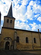
Church of the Assumption

Military cemetery


Economy and Infrastructure
There are seven farms in the municipality of Rupt-en-Woëvre (cereal cultivation, dairy farming).
The D21 département road from Génicourt-sur-Meuse to Bonzée runs through Rupt-en-Woëvre . In Haudainville , 13 kilometers away, there is a connection to the A4 Autoroute (Paris – Strasbourg); the Meuse TGV railway station is 22 kilometers southwest of Rupt-en-Woëvre.
literature
- Le Patrimoine des Communes de la Meuse. Flohic Editions, Volume 2, Paris 1999, ISBN 2-84234-074-4 , p. 1106.
supporting documents
- ↑ Rupt-en-Woëvre on cassini.ehess.fr
- ↑ Rupt-en-Woëvre on cassini.ehess.fr
- ↑ Rupt-en-Woëvre on insee.fr
- ↑ Farms on annuaire-mairie.fr (French)