
Nixéville-Blercourt
| Nixéville-Blercourt | ||
|---|---|---|
|
||
| region | Grand Est | |
| Department | Meuse | |
| Arrondissement | Verdun | |
| Canton | Dieue-sur-Meuse | |
| Community association | Val de Meuse-Voie Sacrée | |
| Coordinates | 49 ° 7 ' N , 5 ° 17' E | |
| height | 220-347 m | |
| surface | 19.54 km 2 | |
| Residents | 494 (January 1, 2017) | |
| Population density | 25 inhabitants / km 2 | |
| Post Code | 55120 | |
| INSEE code | 55385 | |
 Town hall (Mairie) of Nixéville-Blercourt |
||

Nixéville-Blercourt is a French commune with 494 inhabitants (as of January 1, 2017) in the Meuse department in the Grand Est region (before 2016 Lorraine ). It belongs to the Arrondissement of Verdun and the canton of Dieue-sur-Meuse (until 2015 Souilly ).
geography
Nixéville-Blercourt is about nine kilometers southwest of the city center of Verdun . Nixéville-Blercourt is surrounded by the neighboring communities of Sivry-la-Perche in the north, Verdun in the northeast, Landrecourt-Lempire in the east, Les Souhesmes-Rampont in the south, Brocourt-en-Argonne in the west and Jouy-en-Argonne in the northwest.
history
1973 the localities of Nixéville and Blercourt were merged to form today's municipality.
Population development
| year | 1962 | 1968 | 1975 | 1982 | 1990 | 1999 | 2006 | 2013 |
| Residents | 155 | 173 | 299 | 421 | 419 | 422 | 427 | 472 |
| Source: Cassini and INSEE | ||||||||
Attractions
- Saint-Léger church in Nixéville, originally from the 12th century, rebuilt in 1825
- Saint-Pierre-ès-Liens church in Blercourt from 1740
- Military cemetery
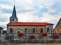
Saint-Léger church

Saint-Pierre-ès-Liens church


literature
- Le Patrimoine des Communes de la Meuse. Flohic Editions, Volume 2, Paris 1999, ISBN 2-84234-074-4 , pp. 891-892.
Web links
Commons : Nixéville-Blercourt - collection of images, videos and audio files